Malyan Hill
Once upon a time, the Elamites lived in a large part of the southwestern Iranian plateau. In the last years of the third millennium BC, the Elamite civilization had reached its peak, but with the coming to power of the Achaemenids (550 BC), the power of the Elamites was limited to the Susa region. Despite the fact that some information about the Elamite and post-Elamite civilizations is available, no significant works have been found related to the pre-Elamite era. However, archaeological findings in some historical sites such as Maylan Hill have provided experts with good information about the ancient history of Iranian civilizations.
Where Is Malyan Hill Situated?
Malyan Hill is a large ancient site with an area of more than 200 hectares, located in Beyza County of Fars Province. This area is located 46 km north of Shiraz and 46 km west of Persepolis. This hill stands 1611 meters above sea level.
The History of the Ancient Malyan Hill
Malyan Hill has been known as an ancient site since the middle of the 19th century AD. In one of the books published in 1896 mention has been made of the existence of certain ruins in this ancient site.
In the 1970s, between 1971 and 1976, certain excavations were carried out in this ancient site under the supervision of an American clergyman and social scientist, named William Sumner, with the presence of a number of researchers from Pennsylvania, Michigan, and Ohio universities. Sumner believed that there would be a lot of evidence pertaining to the Achaemenian era under the layers related to the Sassanid and Islamic eras.
What Historical Period Does Malyan Hill Belong To?
Anshan, Anzan, or Malyan is an important region that belonged to the Elamite civilization and its boundaries are located in the west and center of today’s Fars Province. In the Akkadian and Sumerian texts, Anshan is mentioned as a prosperous land where the Achaemenians settled in the 1st millennium BC. When Cyrus the Great entered Babylon in 539 BC, he called himself “King of Anshan” and “descendant of Chishpish” (Teispes). New discoveries show that Chishpish had come to power around 635 BC before which date, i.e. between 648 and 635 BC, the Elamites were engaged in a war with Assyria, and a group called “Anshani” by archaeologists, ruled the region.
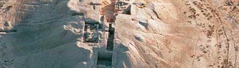
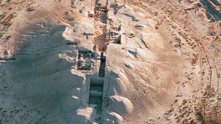
Archaeological Findings during Malyan Hill Excavations
The first excavations in this ancient hill were proposed as a search operation for a lost city; a title that gained more attention after the discovery of an Elamite cuneiform inscription written by an Elamite king toward the end of the second millennium BC.
The most important works related to the middle Banash civilization (3250 to 3000 BC) were obtained from Malyan Hill. In addition, the walls of an ancient city related to the last Banash civilization (3000 to 2700 BC) have also been found, which probably had an area of 200 hectares. This city had been built using clay bricks and it was the contemporary of Susa civilization. The foundation of the exterior part of the walls of the city was made of stone to give it more strength. The thickness of the walls was probably about five meters and extended to about five kilometers in order to protect the city against attacks. The existence of such a thick wall shows that there were possible threats from enemies who could break through the normal walls with the war techniques of their time.
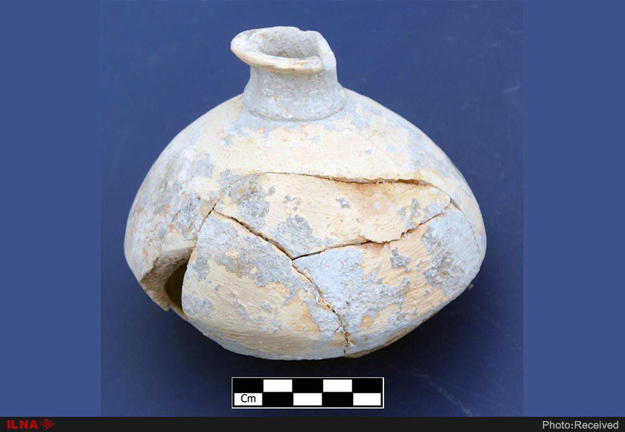
Several Elamite clay tablets dating back to 1300 to 1000 BC have also been discovered in this hill, most of which are kept at the University of Pennsylvania.
Several pieces of pottery work belonging to the Achaemenid period have also been obtained, which are kept in the National Museum of Iran. The excavations of Malyan Hill have manifested a specific framework of the processes related to the formation of the area, its settlement stages, the written findings of the Elamite era and monuments, large buildings, and urban structure.
Due to its historical importance, Malyan Hill was inscribed on the list of Iran’s national heritage in the year 1975 AD.
In the 1970s, between 1971 and 1976, certain excavations were carried out in this ancient site under the supervision of an American clergyman and social scientist, named William Sumner, with the presence of a number of researchers from Pennsylvania, Michigan, and Ohio universities.
لامیها آثار قابل توجهی بر جای نمانده است. با این حال یافتههای باستانشناسی در برخی محوطههای تاریخی همچون تپه ملیان، اطلاعات خوبی درباره پیشینه تمدنهای ایرانی در اختیار کارشناسان قرار داده است.تپه ملیان در کجا قرار دارد؟
تاریخچه محوطه باستانی تپه ملیان
تپه ملیان به کدام دوره تاریخی تعلق دارد؟
یافتههای باستانشناسی کاوشهای تپه ملیان
ثبت ملی تپه ملیان
| Name | Malyan Hill |
| Country | Iran |
| State | Fars |
| City | Beyza |
| Type | Historical |
| Registration | National |


Choose blindless
Red blindless Green blindless Blue blindless Red hard to see Green hard to see Blue hard to see Monochrome Special MonochromeFont size change:
Change word spacing:
Change line height:
Change mouse type: