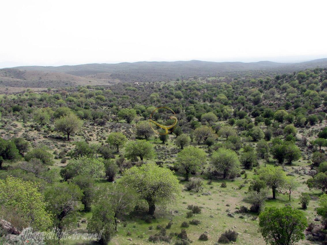
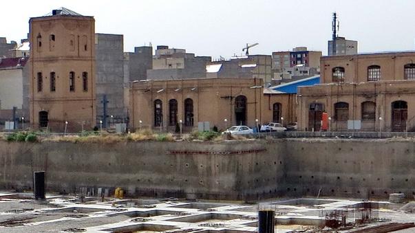
Molla Hadi Sabzevari Mausoleum – Scholar of Philosophy and Islamic Sciences
Molla Hadi Sabzevari was an Iranian scholar and thinker in the fields of humanities, philosophy, and poetry, born in 1797 CE (1176 SH) in Sabzevar, a city in northeastern Iran. He began his education in his hometown, studying the foundational sciences, and later moved to Mashhad, near Sabzevar, to further complete his studies.
Life and Works of Molla Hadi Sabzevari
During Molla Hadi’s time, Isfahan was the capital of the ruling government (the Safavid dynasty) and one of the main scientific and intellectual centers of the era. As a result, the city was a major destination for students seeking knowledge. After completing his studies in Mashhad, Molla Hadi traveled to Isfahan to study philosophy and mysticism. While in Isfahan, he benefited from the teachings of renowned scholars of the time, including Molla Hossein Sabzevari, Sheikh Mohammad Taqi Razi, Mohammad Ebrahim Kalbasi, Molla Ali Mazandarani, and Molla Esmail Koushki.
Afterward, Molla Hadi spent some time in Kerman and eventually returned to Mashhad in 1827 CE (1206 SH), where he taught for five years at a school called Haj Hassan School. He later returned to his hometown of Sabzevar, where he continued teaching until the end of his life.
Works and Contributions of Molla Hadi Sabzevari
Molla Hadi Sabzevari was also skilled in composing mystical and philosophical ghazals, and in his poetry, he used the pen name “Asrar” (a takhallus, or pseudonym that poets use, usually in one of the final couplets to sign their work).
Several books by Molla Hadi Sabzevari have survived, the most important of which include:
-
Asrar al-Hekmah fi al-Muftatah al-Mughtanam
-
Al-Nibras fi Asrar al-Asas
-
Divan of Poems
-
Rah Qarah and Rahiq on the science of Badi‘ (rhetoric and literary style)
-
Miftah al-Falah and Misbah al-Najah
-
Rasa’il Hakim Sabzevari
Molla Hadi Sabzevari passed away at the age of 77 in 1873 CE (1250 SH) and was buried on his private property in Sabzevar. A year after his death, Mirza Yusuf Mostofi-al-Mamalek, a prominent official of the Qajar government, built a mausoleum in his honor.

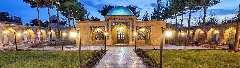
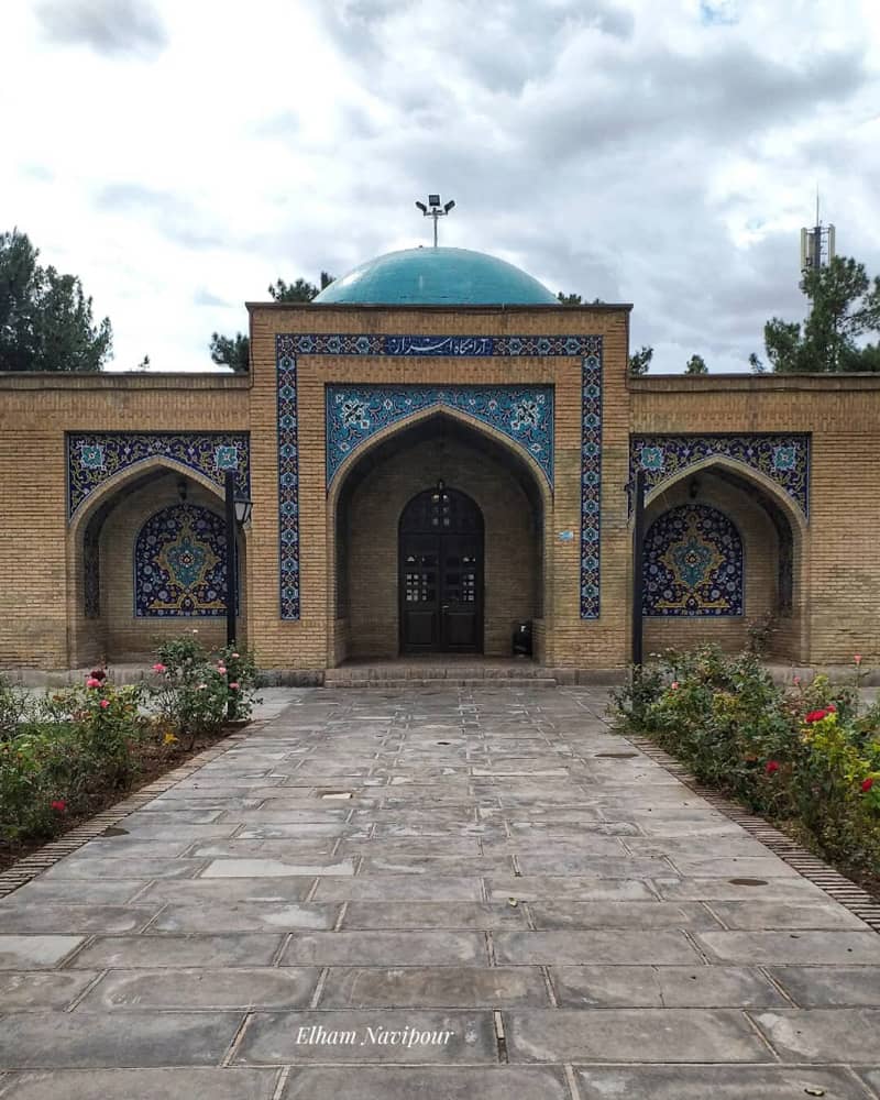
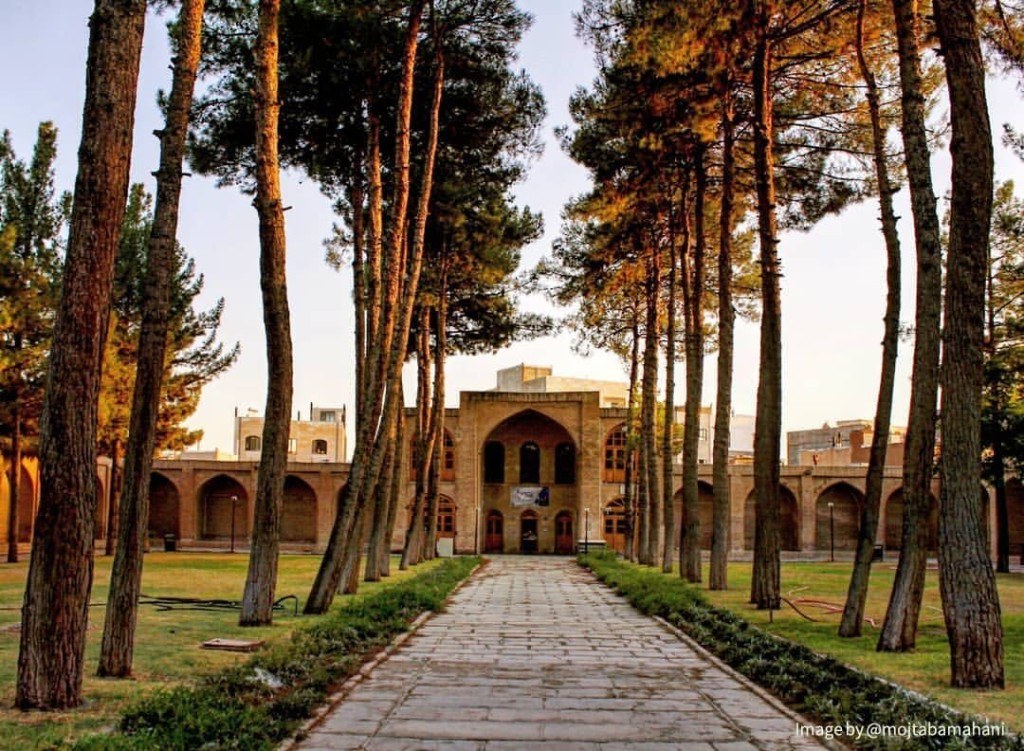
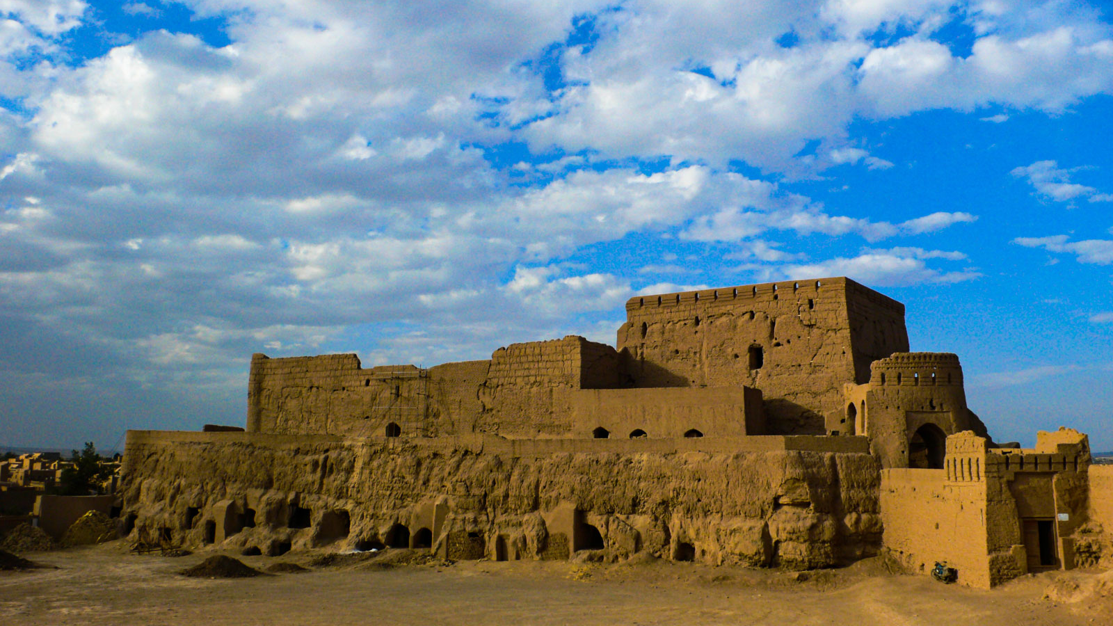
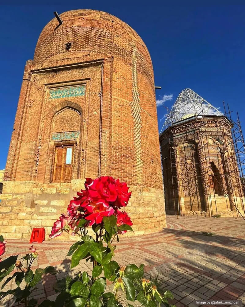
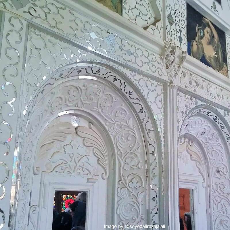
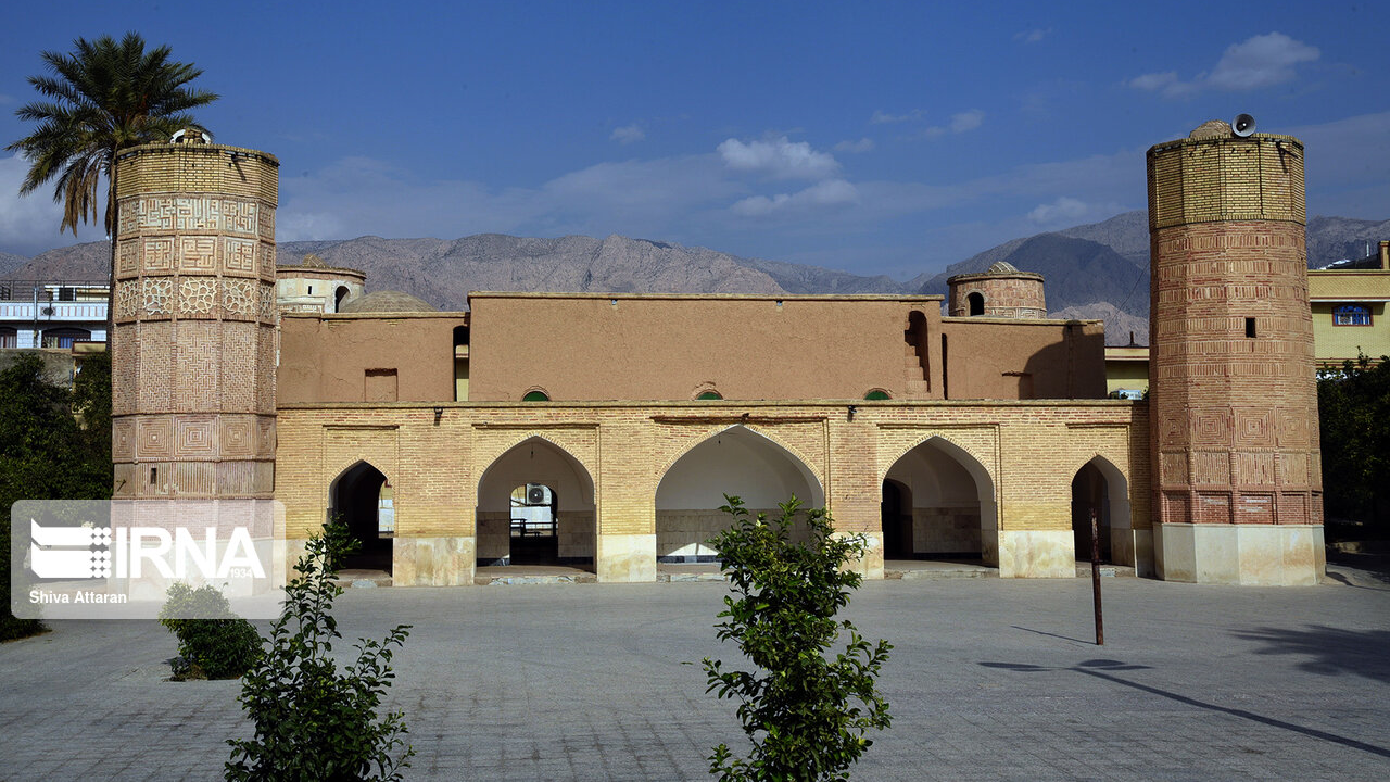
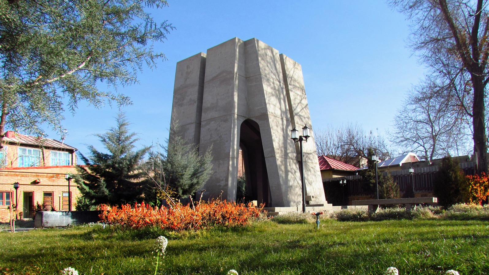
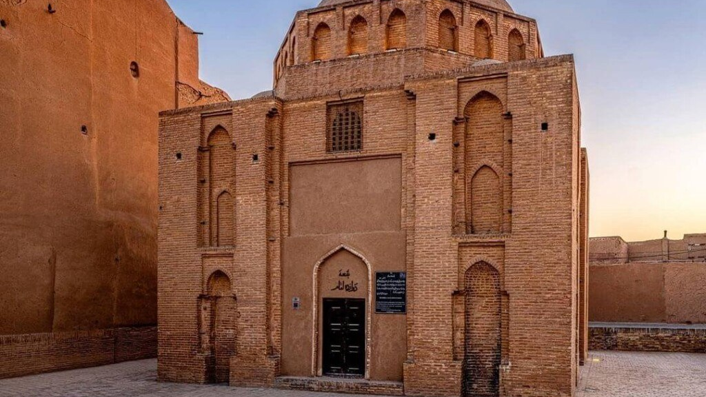
The Mausoleum of Molla Hadi Sabzevari in Sabzevar
Mirza Yusuf intended to establish a school next to the mausoleum so that Molla Hadi’s eldest son, Molla Mohammad, could teach there. However, due to Molla Mohammad’s death, the construction of the school was left unfinished, with only a few rooms completed.
The Mausoleum of Molla Hadi has been restored in recent years, which has helped prevent its destruction. In 1961 (1340 AH), decorative elements were added, enhancing its grandeur and beauty. Its inclusion in the National Heritage List of Iran in 1976 (1355 AH) reflects its historical significance.
The Mausoleum of Molla Hadi Sabzevari is popularly known among the people of Sabzevar as the Mausoleum of Asrar, named after his pen name (takhallus), Asrar.
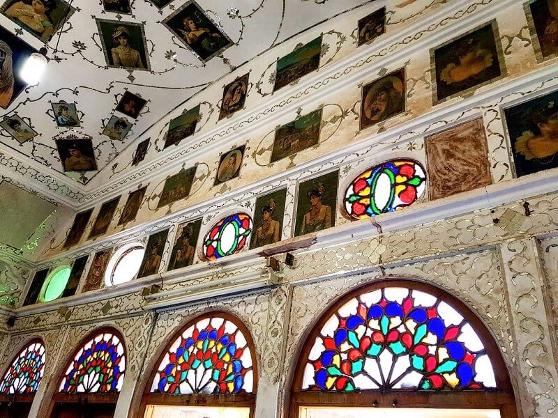
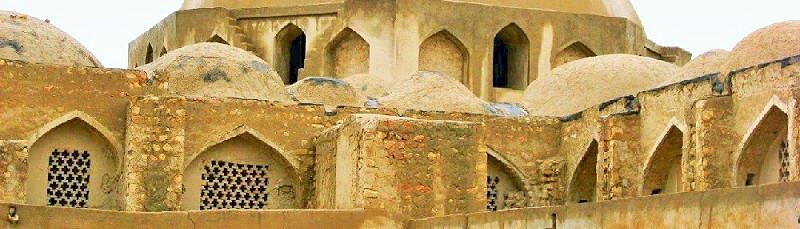
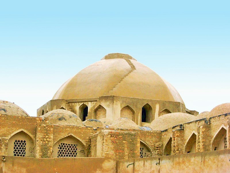
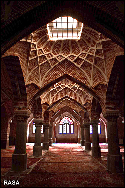
The building consists of a main hall and four iwans and is entirely constructed with bricks and gypsum mortar. A brick dome adorned with blue tiles sits atop the mausoleum. Unlike typical Iranian architecture, the dome of Molla Hadi Sabzevari’s mausoleum is composed of several semicircular sections. For this reason, the lapis-colored dome is more vulnerable to natural disasters, and cracks have formed on its plaster surface.
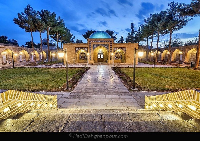
At the northeast entrance of the mausoleum, mirror-work decorations can be seen on the ceilings of the main hall and the iwans, creating a visually stunning effect. The eastern and western iwans of the main hall each have three skylights, which provide natural lighting to the interior.
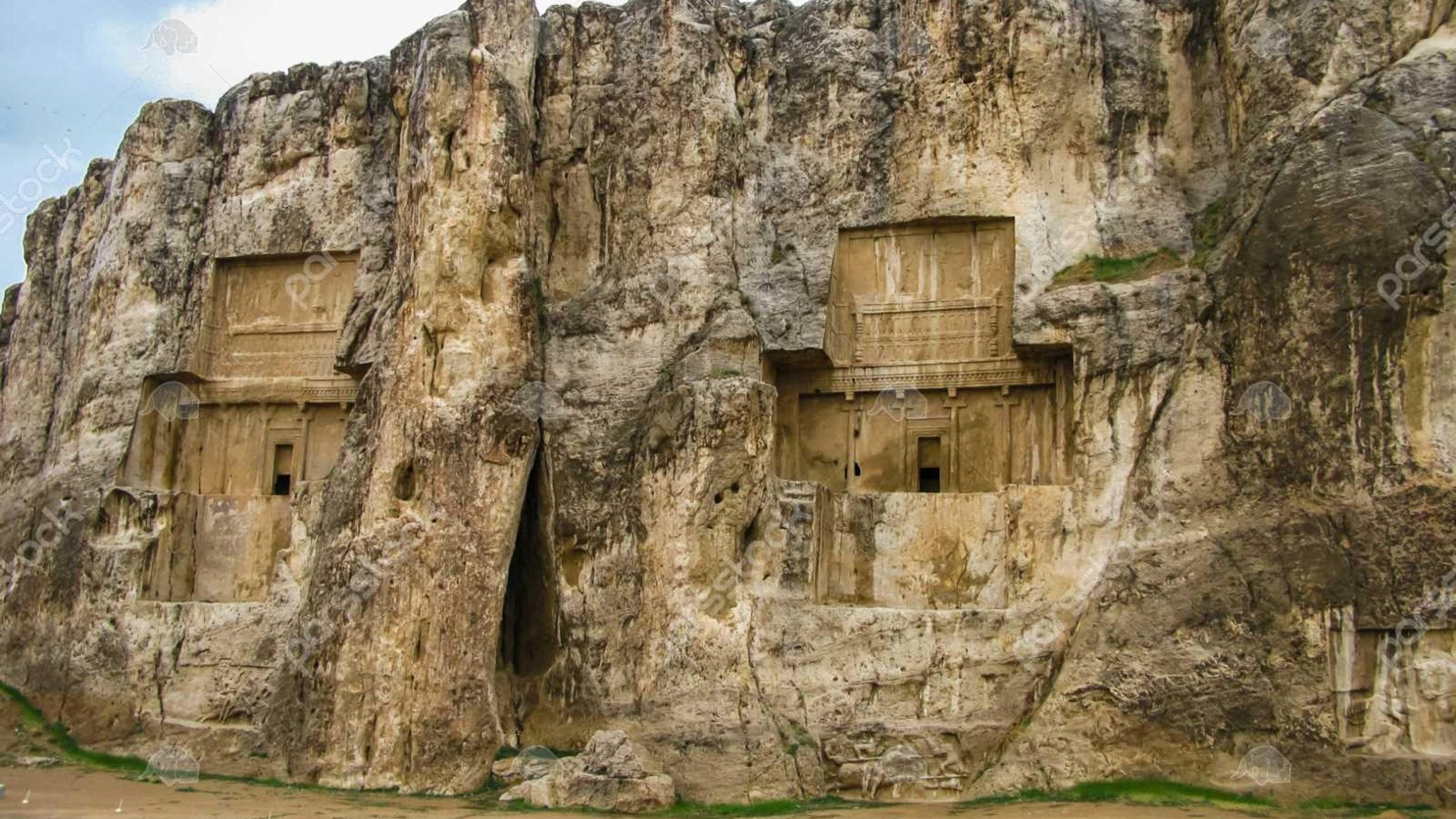
The overall structure of the mausoleum is based on the Chalipa design. Chalipa, or the Iranian cross, is a cross-shaped architectural plan that has been observed in Iranian architecture since the millennium before Christ. Notable examples of this design include the massive walls of Naqsh-e Rustam.
In the center of the main hall, there is a large marble tombstone belonging to Molla Hadi Sabzevari. Apparently, the original tombstone was made of plaster, over which a wooden chest was once placed.
The grounds of the mausoleum are also very attractive, featuring four gardens—two located in front of the main hall and two on its eastern and western sides. Additionally, the building includes two small chambers and two porches.
National Registration of Molla Hadi Sabzevari Mausoleum
This monument was registered on July 31, 1976 (9th of Mordad 1355 in the Iranian calendar) with registration number 1344 on the list of Iran’s National Heritage Sites.
| Name | Molla Hadi Sabzevari Mausoleum – Scholar of Philosophy and Islamic Sciences |
| Country | Iran |
| Type | Historical |


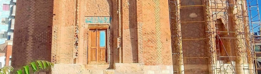
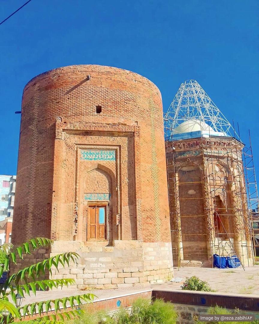
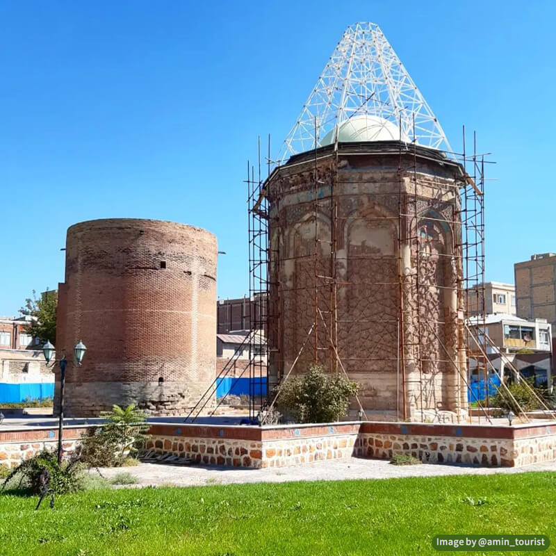
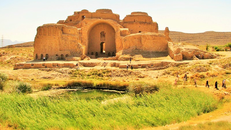
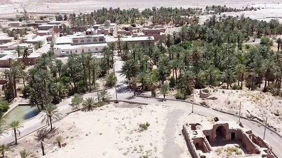
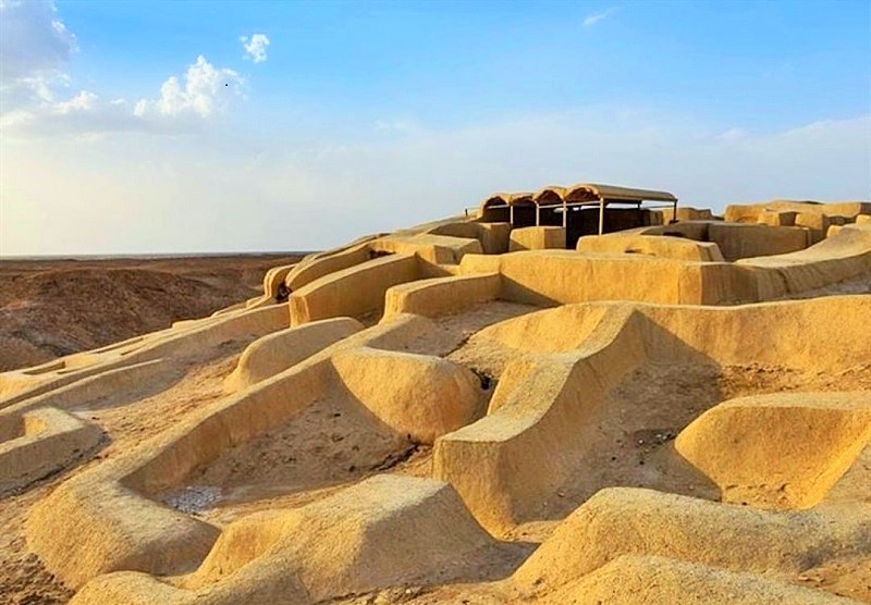
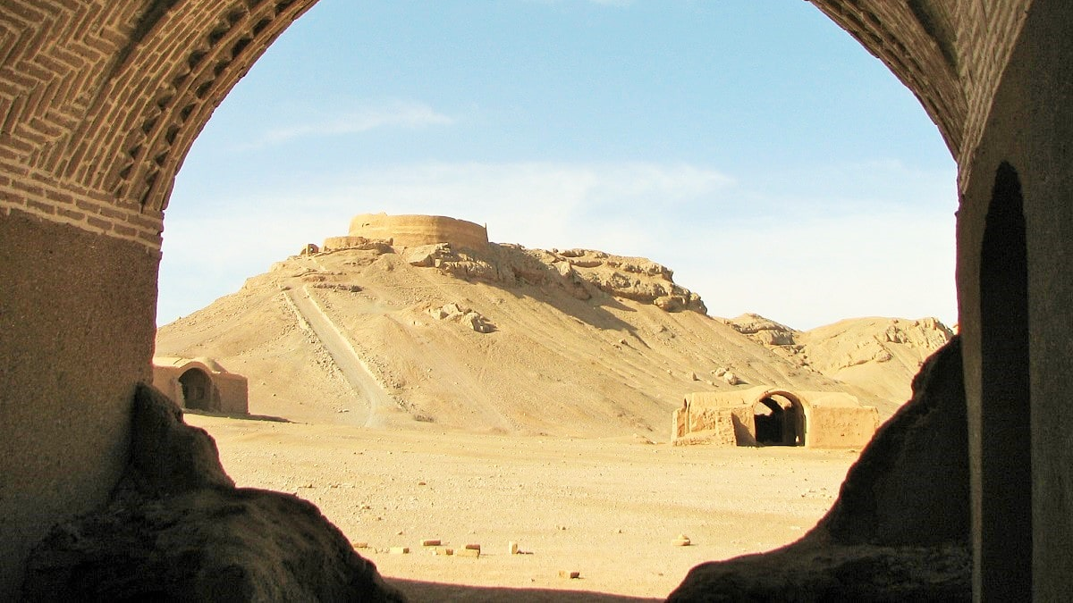
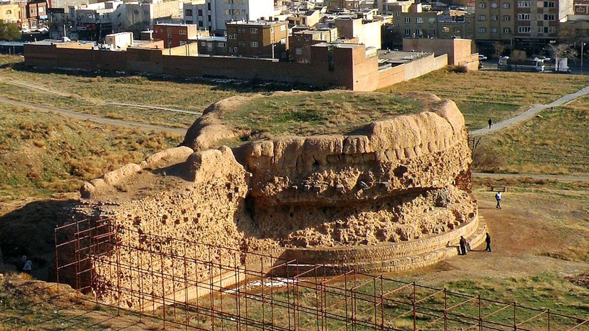
Circular Tower of Maragheh
Maragheh is one of the northwestern cities of Iran, where numerous historical monuments are located. This city is one of the most populated cities of West Azarbaijan Province and is known as one of the scientific centers of the Seljuq era and one of the capitals of the Ilkhanate (along with Tabriz and Soltanieh) dynasty.
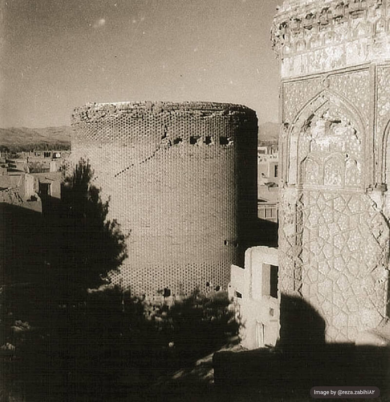
The existence of the historical Maragheh Observatory, which was, once upon a time, an international center of scientific research, speaks of the scientific and political importance of this city at that time. The Circular Tower of Maragheh is one of the historical monuments of this city, is, in fact, a tomb but the identity of the person buried in it is not known. Of course, according to some experts, prior to being a tomb this site was used as a defense fort.
The Circular Tower of Maragheh can be considered as one of the historical towers of Maragheh. Gonbad-e Sorkh (Red Dome), Gonbad-e Kabud (Blue Dome), Ghaffarieh Dome, and Gouy Tower, which was completely destroyed in 1938 AD, are the other towers of this city. These towers are, in fact, a set of tombs built in the form of domed towers, which were constructed mainly during the 13th to 15th centuries AD (6th to 8th AH) in Maragheh, and all of them were inscribed on the list of Iran’s national historical heritage in the year 1932 AD.
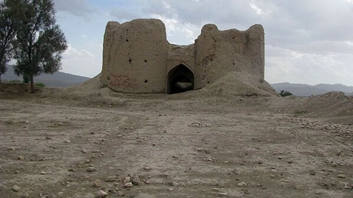
The Architecture of Circular Tower of Maragheh and the Materials Used in Its Construction
The Circular Tower of Maragheh has a portal with a frame and a crescent-shaped arch, in which there is an inscription decorated with bricks and turquoise color tiles. The date of the construction of the building mentioned in this inscription is 563 AH (1167 AD), which coincides with the era of Seljuq rule. In this period, a lot of importance was given to the construction of tower-shaped tombs and minarets such that the number of these buildings was more than mosques. The architects of the Seljuq era had a special skill in building domes and used brickwork as the main way to decorate the facade of buildings.
There is a room above the cellar, called the “Upper Room”, which had stucco decorations in the past, but these decorations have disappeared over time. There are no special decorations on the exterior of the building and the entire area is covered with ordinary brickwork.
Carved limestone and clay bricks were used to build the Circular Towe of Maragheh. The main mortar used in this building is Sarooj, which is one of the oldest Iranian mortars and has been used in the construction of many buildings throughout Iran. The strength of Sarooj had made it one of the most widely used materials in Iran’s construction before the widespread use of cement.
Despite being strengthened with the use of Sarooj the two-layered dome and the roof of the Circular Towe of Maragheh have been destroyed over time. In later periods, a gable roof was built on the structure to prevent its complete destruction. However, since the construction of this gable changed the characteristics of the building to some extent, it was somehow amended to preserve the originality of the building.
Buildings Adjacent to the Circular Towe of Maragheh
Having seven towers known as “Maragheh Domes”, Maragheh has been known as the “City of Towers”. These buildings are located at a short distance from the Circular Towe of Maragheh.
Presently, only four of the seven towers of Maragheh are left, which include the Circular Towe of Maragheh, the Red Dome, the Blue Dome, and the Ghaffarieh Dome. The Red Dome is one of the oldest buildings of the Islamic era, the Blue Dome, like the Circular Tower of Maragheh, belongs to the Seljuq era, and the Ghaffarieh Dome was created a little later, during the Ilkhanate period. Ghaffarieh Dome, which is said to have been built by Sultan Abu Saeed Bahadur Khan, is a brick and square building located on top of a stone platform and contains a deep crypt.
The Circular Towe of Maragheh was inscribed on the list of Iran’s national heritage in the year 1932 AD.
The Circular Tower of Maragheh has a portal with a frame and a crescent-shaped arch, in which there is an inscription decorated with bricks and turquoise color tiles. The date of the construction of the building mentioned in this inscription is 563 AH (1167 AD).
| Name | Circular Tower of Maragheh |
| Country | Iran |
| State | East Azerbaijan |
| City | Maragheh |
| Type | Historical |
| Registration | National |
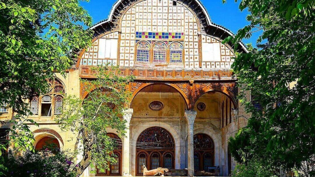

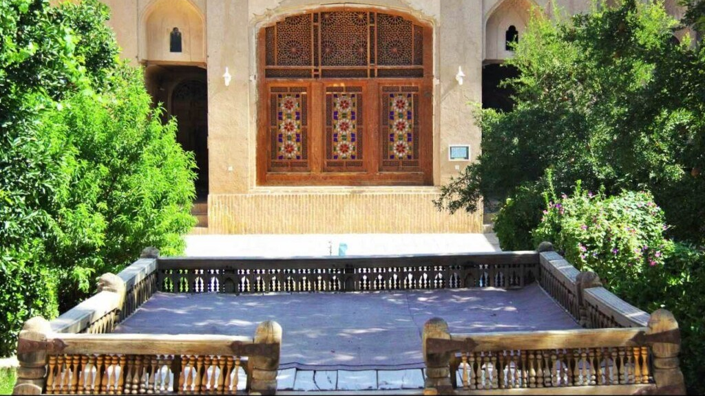
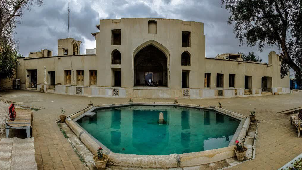
House of Laris
Fahadan is one of the oldest neighborhoods of Yazd and has many historical sites. The House of Laris, which is one of these sites and is related to the Qajar era (1796 to 1925 AD), was built by a famous businessman named Haj Mohammad Ebrahim Lari in the year 1869 AD. He was originally from the Lar City of Fars Province and had settled in Yazd during the Qajar era.
This mansion is neighbored by other historical sites like Ziaiyeh School (previously Alexander’s Prison), Davazdah Imam Memorial, and Yazd Citadel.
The History of the House of Laris
The House of Laris was built by a tradesman from the city of Lar by the name of Haj Mohammad Ebrahim Lari during the Qajar era who lived in this house until around the end of the reign of Pahlavi I (around 1941 AD). After his death, there was a dispute among the heirs, and as a result, the house remained abandoned for 50 years during which it was used as a monastery by dervishes.
In 1984 the Cultural Heritage, Handicrafts, and Tourism Organization of Yazd Province took over the management of this mansion and took the necessary measures to restore it. Presently, a part of the mansion is used as a document museum and another part is used as the administrative office of this Organization.
The Architecture of the House of Laris
Windcatcher, which is one of the components of desert houses, can also be seen in this mansion. This house was built on a plot of 1700 square meters with an infrastructure of nearly 1200 square meters. Clay, mud, brick, straw, mortar, and plaster have been used in the construction of this house. There are two entrances to the house in the west and north, of which the one in the west is the main entrance of the building. This entrance is built with a vestibule and leads to the main courtyard.
Based on the principles of the Iranian style of architecture, the House of Laris has two internal and external parts. There are three courtyards in the mansion, one of which is located in the northeast and is separated from the other two courtyards. The entrance to this courtyard is independent.
The middle yard is smaller than the main yard. There is a vestibule in the middle of the main courtyard and the middle courtyard. A seven-door room in the northwest, a five-door room, and a three-door room have been created in the northeast of the middle courtyard. The carved wall in front of the seven-door room looks quite beautiful.
The main courtyard of the house is located in its west. A beautiful pond has been built in the middle of it and a bed can be seen on it. This part of the building is known as the “Ghorub/Sayeh Neshin” (lit. A place to spend time after sunset). In hot summer days, this part of the mansion was used as a resting place by the residents of the house.
Several structures and rooms can be seen on four sides of the main courtyard. A total of 22 rooms were built in this mansion, which have been often decorated with mirror work. One of the rooms in the eastern part, which is known as the mirror room, is considered the most beautiful part of the mansion.
The southern parts, which receive less sunlight, were used for living in the summer, and the northern parts, which absorb the sunlight and heat more, were used during winter. The southern part has a large porch and a high windcatcher. Some small windcatchers have also been created in this area, whose job is to act as air-conditioners and cool the space inside the building. The height of the south porch makes the rooms be in shade so that the intensity of the sunlight is reduced.
The main kitchen of the mansion is located in the eastern part, which was used in autumn. In the spring, the residents of the mansion used to go to its western part.
This mansion has a cellar, which is located under the porch and is connected to the yard by a few steps. This cellar was mainly used for storing food materials such as meat, beans, etc. The ceiling of the porch is in the form of an arch and is covered with straw and plaster. This form of architecture is known as “Toizeh Arch”. Even the cellar of this mansion has been decorated with two colored shamsas (decorative patterns looking like the sun). Sometimes, on hot summer days, the residents of the house took refuge in the cellar to escape the existing heat.
The third courtyard, which is smaller than the other two courtyards, has only one room. Probably, this yard was an environment for family members to withdraw from others and to rest in seclusion.
The House Laris was inscribed, as a national monument, on the list of Iran’s national heritage in the year 1996 AD.
The House of Laris, which is one of these sites and is related to the Qajar era (1796 to 1925 AD), was built by a famous businessman named Haj Mohammad Ebrahim Lari in the year 1869 AD.
| Name | House of Laris |
| Country | Iran |
| State | Yazd |
| City | Yazd |
| Type | Historical |
| Registration | National |


_0.jpg)
_crop_3.jpg)
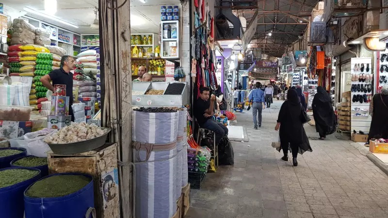
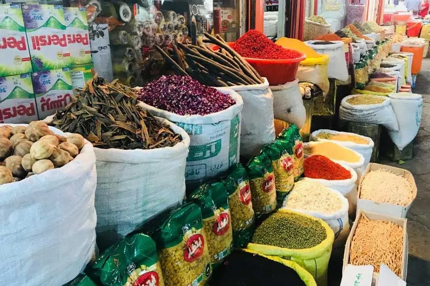
Qaysariyeh Bazaar of Lar; the Oldest Bazaar of Iran
Bazaars were considered one of the most important urban centers in ancient Iran, which have preserved their importance in many cities even today.
Where Is Qaysariyeh Bazaar of Lar located?
Larestan is a city located in the south of Fars province and has a hot and dry climate. Difficult climatic conditions have made farming in this city very difficult, but Lar’s location between the two important cities of Shiraz and Bandar Abbas has made it an important commercial center. Due to its commercial position and interactions with the Persian Gulf countries, Lar is considered one of the richest cities in Fars province.
History of Qaysariyeh Bazaar of Lar
Founded and built by a person named Hossein Asoudeh, who was one of the famous and powerful architects of his time, Qaysariyeh Bazaar of Lar can be considered the oldest market in Iran, where a complete set of daily goods and products is offered. According to some historical sources, the idea for the formation of Shiraz’s Vakil Bazaar, Isfahan’s Bazaar of Chit-makers, and Bukhara’s Bazaar was inspired by this Bazaar. Although this bazaar has been renovated and repaired many times, but its shape and design have not seen major changes in the past 400 years.
The reason for choosing the name Qaysariyeh (there are many bazaars with this name in Iran) is that this name refers to a long corridor that was exclusively dedicated to the supply of delicate and valuable goods such as gold and jewelry. In fact, Qaysariyeh Bazaar of Lar had originally been the place of supply of such goods and it was later on that other guilds gradually appeared there.
There are different opinions about the age of Qaysariyeh Bazaar of Lar. Some people date it back to 900 years ago, and others date its construction to 1350 years ago. However, considering each of these possibilities, it goes without saying that it should be considered the oldest market in Iran and a role model for building other markets.
Features of Qaysariyeh Bazaar of Lar
A collection of traditional Iranian art from the pre-Safavid era (before the 16th century) can be found in this bazaar. There are several caravanserais around it, which were used to accommodate of merchants and commercial caravans in the past.
The best materials, mainly rocks - which are found abundantly in the lands around the city - and the highest architectural knowledge of that time had been used for the construction of this market such that the 1960 earthquake, which caused a lot of damage in Lar and its surrounding areas, had no effect on this bazaar.
The Architecture of Qaysariyeh Bazaar of Lar
This bazaar is designed in a cruciform shape and a unique octagonal dome has been created in its center. The ceiling of the bazaar is about 18 meters above the floor, and a skylight is installed in the middle of each arch. In addition to providing light, these skylights also ventilate the air and make the air in the bazaar 10 degrees cooler than the surrounding environment in the hot summers of Lar. The high arches of the bazaar are quite unique in comparison to all other Iranian bazaars.
The most important manifestation of the art of the architect of this bazaar is manifested in its middle square where a dome is built and reinforced with certain structures called “Khashkhashi”. This method of strengthening the dome was later used in some of the most important domed buildings in Iran, including the Imam Mosque of Isfahan.
Each of the four main passages connects to the central space and has its own name:
• South Passage: “Rastehye Meidan” (Passage to the Square)
• North Passage: “Rastehye Aabforoushan” (Passage of Water sellers)
• Western Passage: “Rastehye Kamargiri” (Passage of Wrestling)
• Eastern Passage: “Rastehye Qassabha” (Passage of Butchers)
The design of the market is such that it provides the possibility to see all the chambers. The atmosphere of the Qaysariyeh Bazaar of Lar still maintains its old structure and the merchants of the same goods have their chambers close to each other.
Qaysariyeh Bazaar of Lar was inscribed on the list of Iran’s national heritage in 1938.
| Name | Qaysariyeh Bazaar of Lar; the Oldest Bazaar of Iran |
| Country | Iran |
| State | Fars |
| City | Lar |
| Type | Historical |
| Registration | National |


-k- main.jpg)

.jpg)

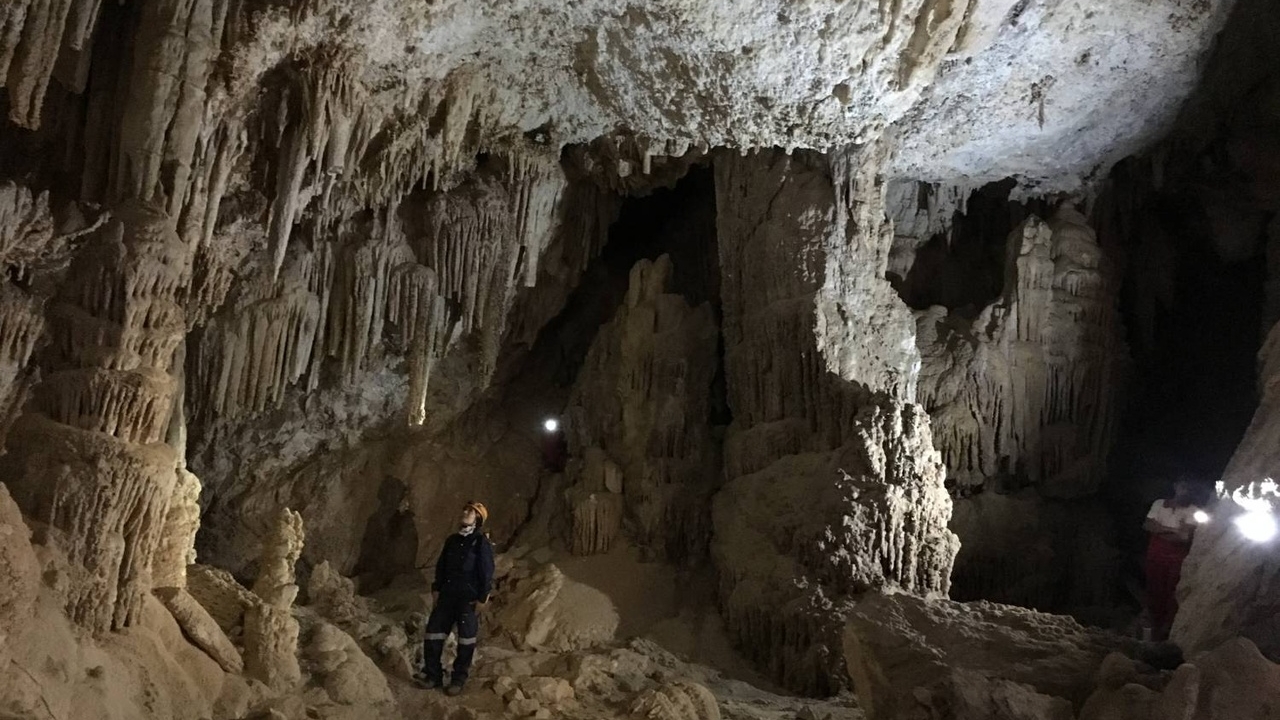
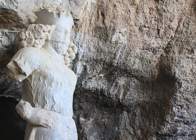
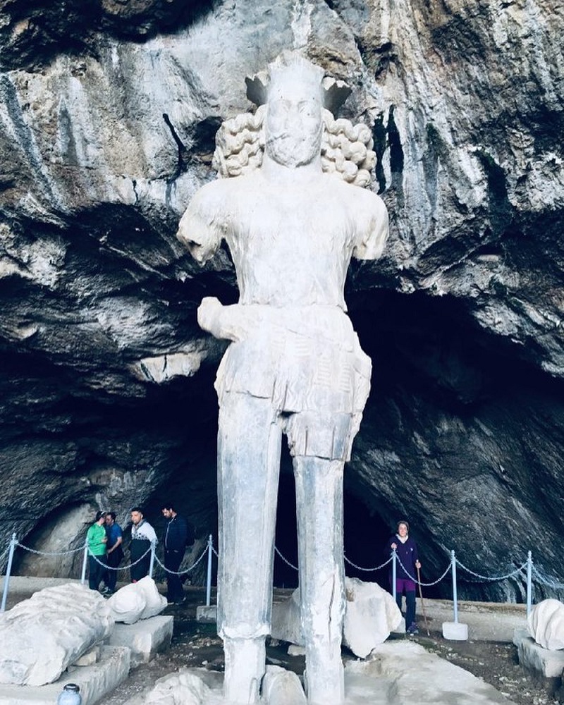
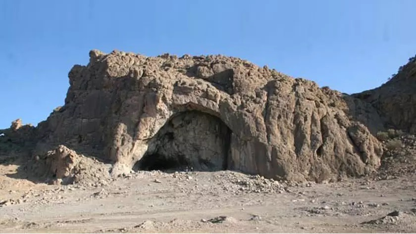
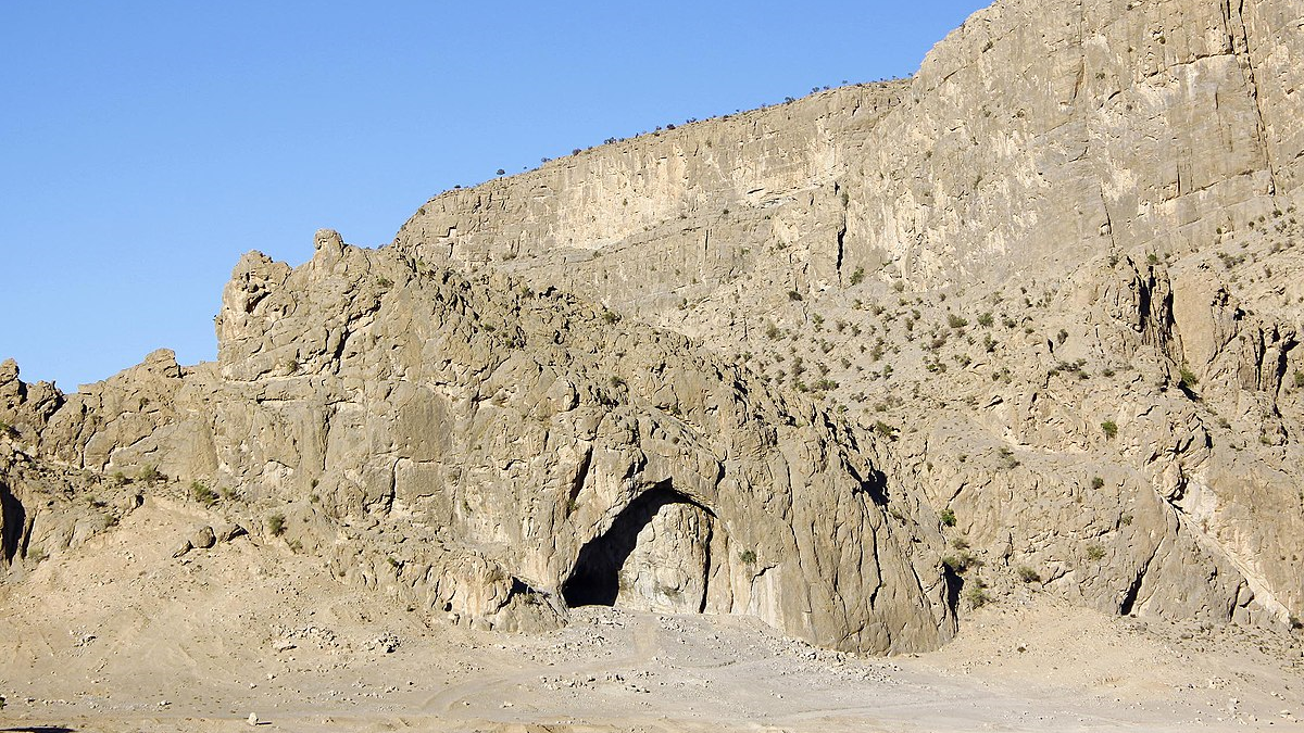
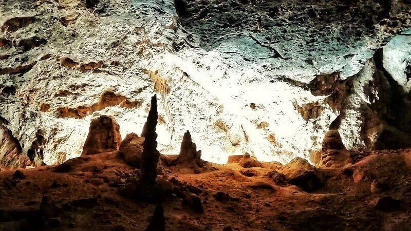
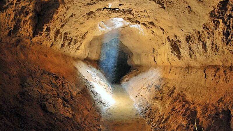
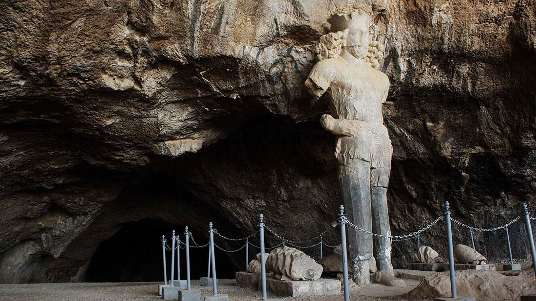
Shapur Cave; An Astounding Cave Housing the largest Statue of Ancient Iran
Located in the Chogan Valley of the Zagros Mountains in Kazerun, Shapour Cave is about six kilometers away from the ancient city of Bishapur. The big statue of Shapour I, the second Sassanid king (reigned from 240 to 270 AD) is one of the most important tourist attractions of this strange cave.
Features of Shapour Cave
Shapour Cave is located at an altitude of 800 meters. The entrance of the cave is 30 meters wide and 15 meters high. It is about 450 meters from the entrance to the end of the cave. The reason for naming it Shapour Cave is the large statue of Shapour I in it.
This seven-meter tall statue, the width of whose shoulders stands at about two meters was carved on one of the stalagmites of this limestone cave some 1700 years ago in the third century AD and is the only statue of this size left from ancient Iran.
Who Was Shapour I?
Shapur I was one of the most powerful kings of Iran who defeated the Romans in a tough war. In his last battle with Rome (260 AD), he captured the Roman emperor and imprisoned him in the city of Bishapur. Shapour has had the scene in which the Roman emperor has surrendered to him inscribed on the wall of Naqsh-e Rostam.
Other Sights of Shapour Cave
There are two stone inscriptions carved on the walls of the Shapour Cave, one of which is related to the early period of Sassanid rule. This old inscription is attributed to the Sassanid king, Shapour. The other inscription, which was carved in the contemporary era contains an explanation about the re-erecting of the statue of Shapour I. According to this inscription, the statue that had been pulled down after the advent of Islam in Iran was erected again, after 14 centuries, in the year 1957 AD.
There are two reservoirs inside the cave that have been dug into the rock. Each of these reservoirs is about one meter deep and is accessible by climbing down several steps. It seems that these small reservoirs were created by the local people to collect and use the water that dripped from the roof.
A small stream flows from the left side of these reservoirs behind which there are some beautiful stalactite and stalagmite stones.
There is a large hole with a diameter of about 100 meters at the bottom of the cave, which is leftover from a dried lake. This hole is about 30 meters deep compared to the entrance floor of the cave. After passing by the hole, one can see a flat area, on the left side of the cave, which has been structured by local people and according to archeological experts, this area was used for holding ceremonies or offering sacrifices in the past. In this part, the height of the cave ceiling is nearly 40 meters from the floor.
Local people believe that the body of Shapour I is buried somewhere at the bottom of this cave. According to another story told by local people, Shapour took refuge in this cave after being defeated in a battle and was never seen again.
Points to Keep in Mind When Visiting Shapour Cave
Considering the semi-arid climate of the region, if you plan to visit Shapour Cave in spring or summer, take enough drinking water with you. You will also need warm clothes in autumn and winter, because sudden winds may start blowing, which will be very disturbing.
To reach the cave, one has to climb 230 steps from the foothill of the mountain. Another path leading to the cave goes through the steep and winding slopes of the mountain, so be prepared and wear appropriate shoes.
Being inscribed on the list of Iran’s National Heritage in 1932, Shapour Cave was also inscribed on the list of UNESCO’s World Heritage Committee in 2018.
The seven-meter tall and two-meter wide statue of Shapour I was carved on one of the stalagmites of this limestone cave some 1700 years ago in the third century AD and is the only statue of this size left from ancient Iran.
| Name | Shapur Cave; An Astounding Cave Housing the largest Statue of Ancient Iran |
| Country | Iran |
| State | Fars |
| City | Caseron |
| Type | Historical |
| Registration | National |


Lar is a city in the south of Fars province, which is known as the “city without alleys”. Due to its hot and dry weather, Lar has many groves and reservoirs. This city is 330 km from Shiraz and 190 km from Bandar Abbas and has a population of about 70 thousand people.
Traveling to Lar is possible by land. Lar also has an airport with flights to Tehran, Shiraz, Ahvaz, Dubai, Kuwait, Doha, and Sharjah.
Geography of Lar
Lar is 806 meters above sea level, its average temperature throughout the year is 38 degrees Celsius, and its annual rainfall is 203 mm. The summers of Larestan are very hot and rainless but has moderate weather from mid-autumn to mid-spring.
Lar’s Economy
Trade is the main activity of the people of Lar and its economic exchanges with Qatar, Kuwait, UAE, and Oman are impressive. With four towns and two industrial districts, this city ranks first among the cities of Fars province. The production of food and edibles, industrial and mechanical parts, and cellulose materials constitute the main industrial activity of Lar. There are also salt, gypsum, and lime mines in this region.
History of Lar
There was a fire temple in Lar during the Sassanid era (224 BC to 642 AD), which brought this city to the attention of the empire. Since the end of the 4th century AD, this city was the center of minting coins. The ancient roads leading from Firouzabad and Estakhr to the ancient port of Siraf passed through Lar, and for this reason, trade with the people of this city flourished since ancient times. This city continued to exist after the advent of Islam (7th century AD) and played its communicational role. The existence of Qeaysarieh Bazaar of Lar, one of the oldest markets in Iran, reflects this aspect of Lar.
Lar’s Tourist Attractions
The long history of Lar, along with the geographical location of this city, has caused the survival of many historical monuments both inside and outside the city.
Historical Attractions of Lar
The historical attractions that have survived inside the city of Lar and date back to the pre-Islamic era until the 19th century include the Azhdeha Peykar (Dragon Body) Castle of the pre-Islamic era, the tomb of Nader Shah’s mother or “Nane Nader Tower” of the Timurid era (14th and 15th centuries AD), New and Golshan caravanserais, Neshat Garden Mansion, Pir-e Sokh Mausoleum, and Lar Anthropology Museum.
However, the Qeysarieh Bazaar of Lar, which was built in the shape of a cross and is more than 13 centuries old, and has served as the role model for the construction of various other historical markets, is the most tourist attraction of this city. One of the important bazaars built with this model is the Vakil bazaar of Shiraz, which was founded during the reign of Karim Khan Zand (19th century).
From among the tourist attractions on the outskirts of Shiraz mention should be made of Azar Faranbagh or Karian Fire Temple, which is located halfway between Lar and Siraf and is considered one of the largest and most important fire temples of the Sasanian era, Shah Abbas Bridge, which was built on the Shour River during the reign of Shah Abbas I (reign from 1587 to 1629 AD).
Several salt domes have been formed over millions of years and contain such minerals as sulfur, uranium, iron, sulfate, and granite also exist around the city of Lar and are visited by many tourists.
Hormoud Protected Area is also located near Lar, which is more than 201 thousand hectares and hosts various plant and animal species. The conditions of this area are such that allow botanical and zoological research.
The long history of Lar, along with the geographical location of this city, has caused the survival of many historical monuments both inside and outside the city.
| Name | Lar |
| Country | Iran |
| State | Fars |
| City | Lar |
| Type | Historical |
_crop_2.jpg)


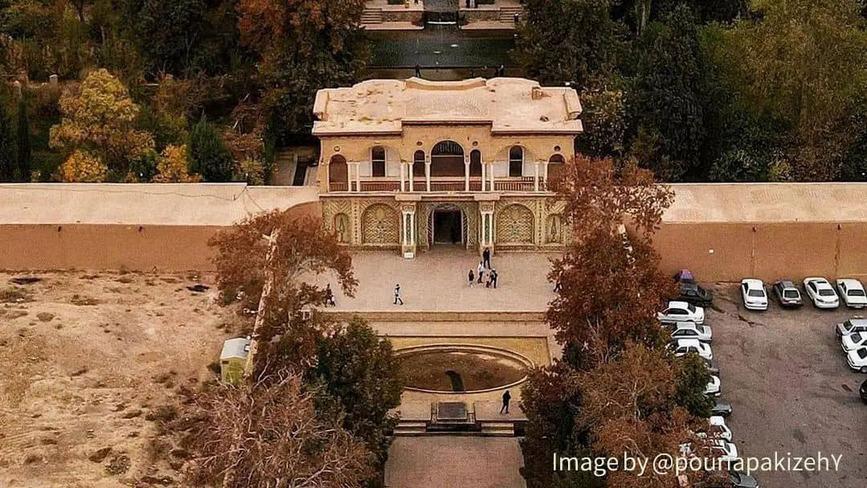
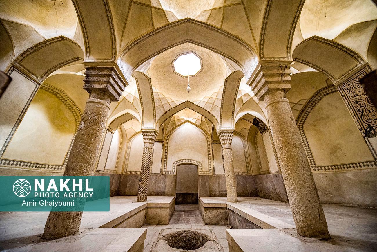
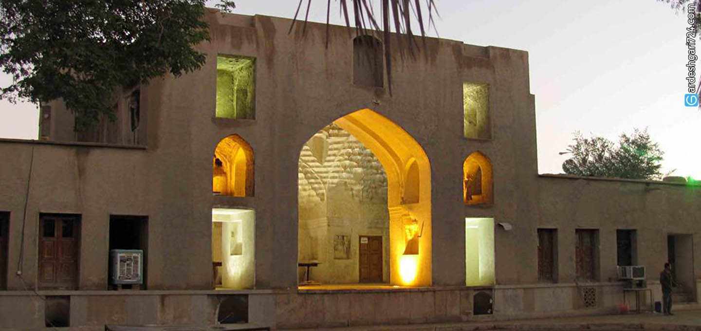
Neshat Historical Garden of Lar
Situated in the heart of the Lar City of Fars Province and near the Qeysarieh Bazaar, Neshat Garden of Lar, which houses palms and plane trees as well as a historical mansion, is one of the tourist attractions of the city.
History of Neshat Garden of Lar
A large area of southern Iran was called “Larestan” in the past. Due to being on the trade route of caravans, this region was given a lot of importance such that a number of sites, like the Qeysarieh Bazaar were built in it during the Qajar era (19th century). Presently, a significant number of people of this city engage in trade with Persian Gulf countries or have settled there.
Lar was a semi-autonomous region during the Safavid era (16th to 18th century) and was administered by local rulers. Neshat Garden of Lar was built in the Safavid era and some parts were added to it in the Qajar period.
Features of Neshat Garden of Lar
The area of this garden is about one hectare and there are a number of buildings in it. In the not-so-distant past, Neshat Garden was the residence of the local rulers. There is a beautiful three-floor mansion in the middle of the garden, the basement of which has been used as Zoorkhaneh (a gym for varzesh-e pahlavāni or varzesh-e bastani of Iran) in recent years.
Architecture of Neshat Garden of Lar
Neshat Garden is built in a rectangular shape on a plot of 35 x 135 meters. The mansion in the middle of the garden has a long and impressive porch whose height is 2.5 meters. There are wooden doors on both sides of the porch and a polygonal stone basin in front of it. An octagonal hole has been installed in the middle of the mansion to provide light and air ventilation. The mansion has been decorated with beautiful muqarnas and plasterwork. All parts of the garden are made in a symmetrical form.
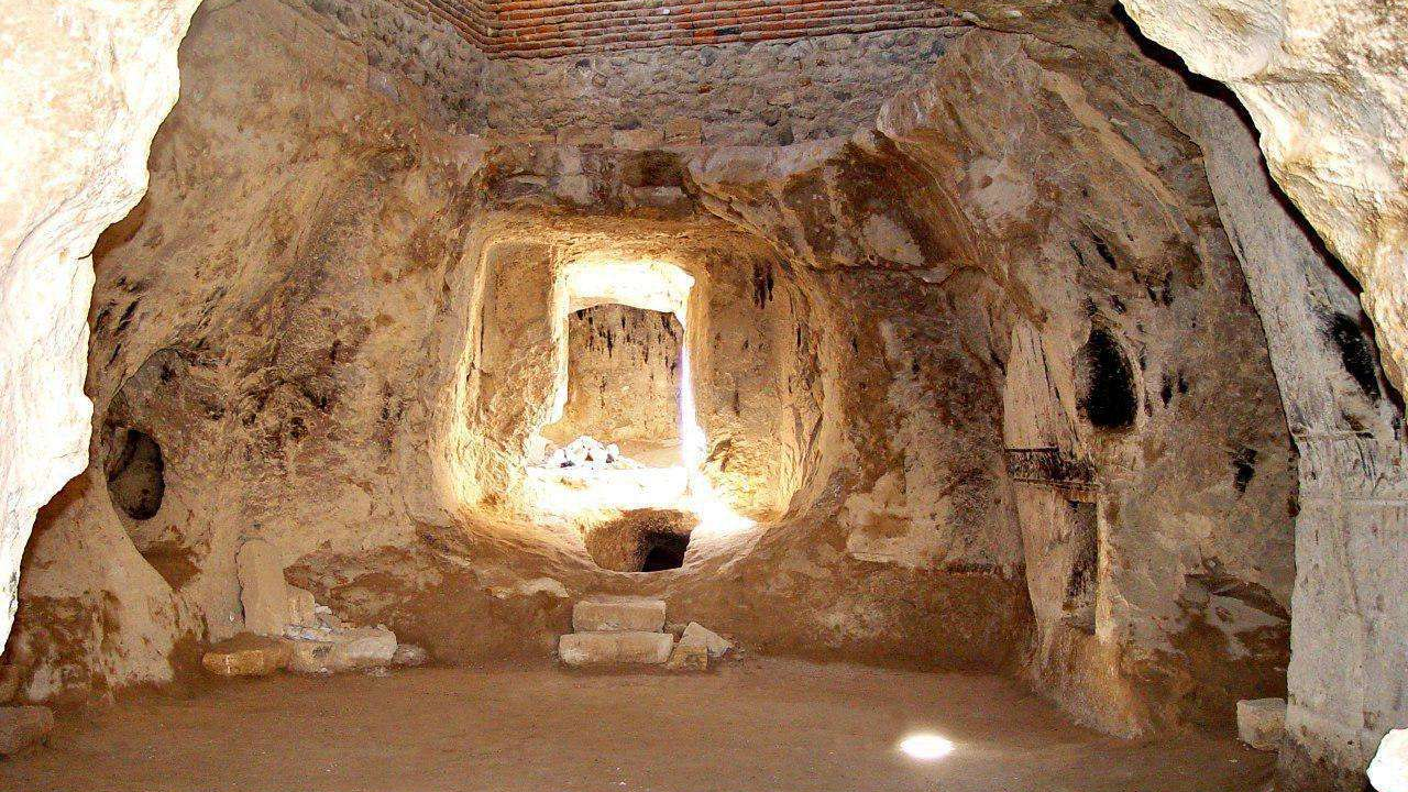
The Bathhouse of Neshat Garden
This bathhouse is located in the north of the garden and it seems that it was built at the same time as the main building of the garden. The crescent-shaped roof as well as the spiral stone columns and plaster works of this bathhouse have given it a special beauty. There are some skylights in the ceiling, which are covered with glass to keep the air warm in the bathhouse.
Like many old Iranian bathhouses, this bathhouse, too, has different parts:
• Entrance: This section is made in a spiral form so that cold air does not penetrate the bathroom. Presently, the main entrance has been closed and an entrance from the garden side has been constructed for it.
• Dressing Area: In this part, there are several platforms for sitting, before and after bathing. There is a small pond in the middle of the area, which was used for washing feet before and after bathing. This pond was filled with cold water.
• Miandar or Sarkhan: An area located between the entry point and main bathing areas with a winding corridor to keep the bathing area warm. There are two ponds on both sides of the miandar, which were filled with hot water from the khazineh (reservoir) to prevent the cold air from the entry point from penetrating the main bathing area.
• Garmkhaneh or main bathing area: Four spiral columns with beautiful limestone decorations support the roof of this part of the bathhouse. There is a skylight in the middle of the ceiling. There are spiral tunnels on the floor of the garmkhaneh through which hot water passed, kept the floor warm, and created a thermal balance in the garmkhaneh.
Neshat Garden of Lar was inscribed on the list of Iran’s national heritage in 2003.
Due to being on the trade route of caravans, this region was given a lot of importance such that a number of sites, like the Qeysarieh Bazaar were built in it during the Qajar era (19th century).
| Name | Neshat Historical Garden of Lar |
| Country | Iran |
| State | Fars |
| City | Lar |
| Type | Historical |
| Registration | National |

_crop_2.jpg)


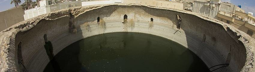
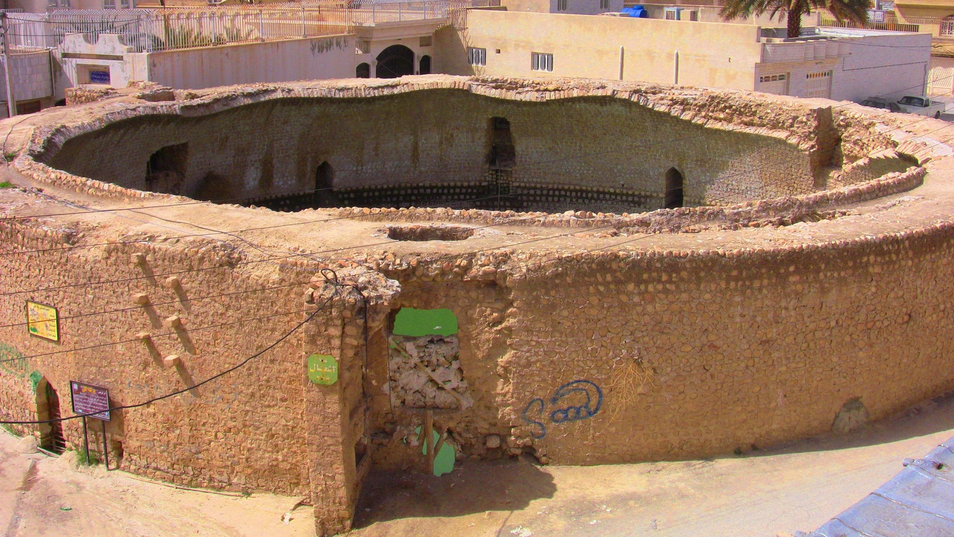
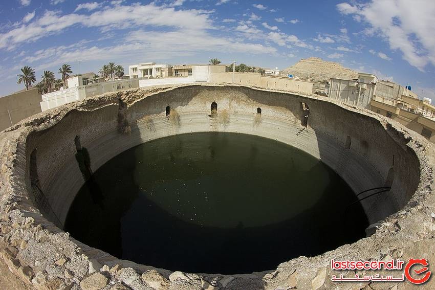
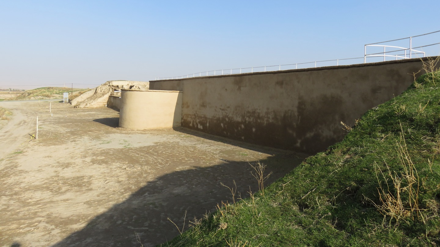
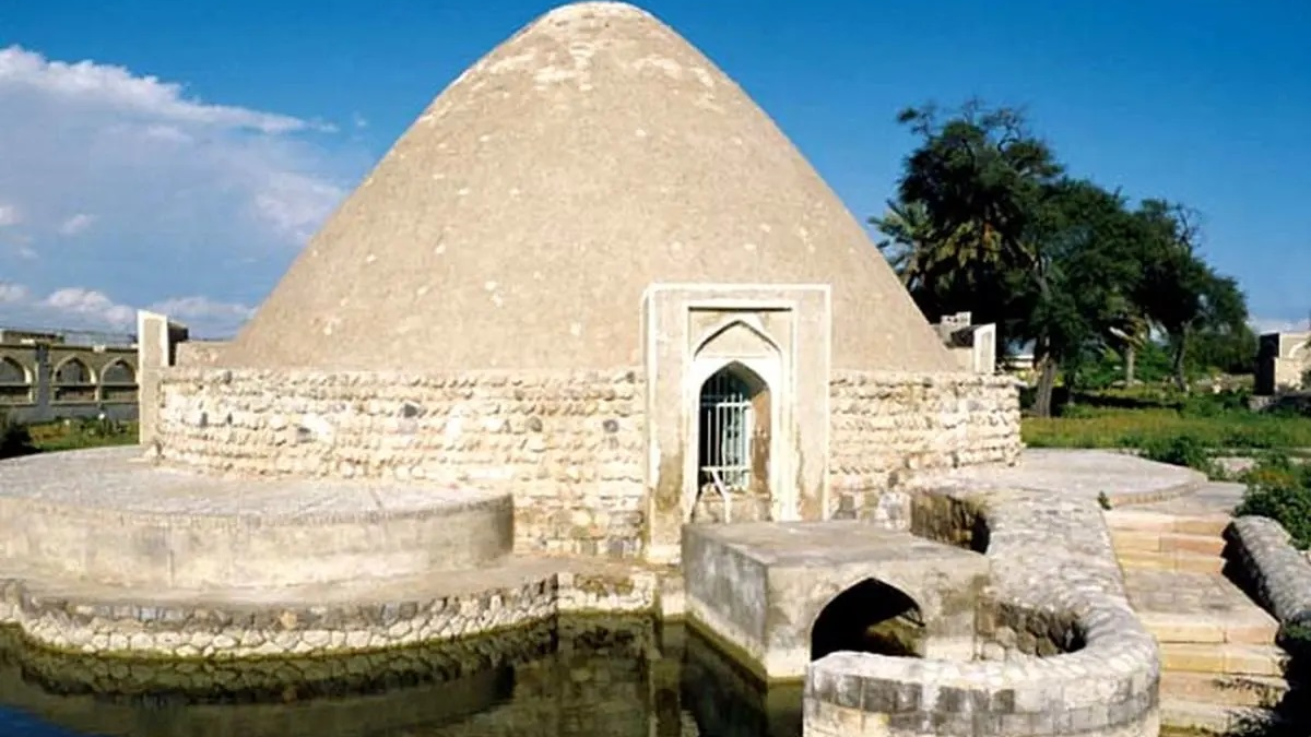
Kal Pond; the Largest Reservoir of Iran
Reservoirs, usually called Aananbar or Berkeh in Persian were built to store water at a height lower than the ground level. In low-water and desert areas, the reservoir was filled with rainwater or seasonal streams in order to use its water in the low-rainy seasons. There are many reservoirs in Iran, and their construction is related to the history of digging the aqueduct. In all probability, the largest reservoir built in Iran is the Kol Pond of Gerash, which is located in the southwest of this city.
Features of the Kal Pond
The construction of Kal Pond, also called Ganj al-Bahr, dates back to the Qajar era (18th century). This reservoir is located on the path of the Tangab seasonal river and it has been built in a place where it can be filled with water in rainy seasons and protected from sunlight and water evaporation in hot seasons. Even today, when many waterways leading to the pond have been destroyed due to the surrounding constructions, the pond gets filled with rainwater.
This pond was built by “Haj Asadollah”, a philanthropist of Gerash, who also built another reservoir near this pond, which is known today as “Asadollah Reservoir”. Although there is no inscription in Kal Pond and the exact date of its construction is not known, it can be attributed to the Qajar period because both reservoirs were built by the same person. Asadollah Reservoir, which was completed in 1869, is the second largest in Gerash.
Nomenclature
Since in the local dialect (Achomi) of Gerash “Kal” means “deaf”, some locals believe that this pond was given the name Kal because it does not have a ceiling and sounds do not get echoed in it. Some other locals, however, believe “Kal” means a hornless sheep and are of the opinion that the pond was given this name because of having no roof, denoting its incompleteness. Of course, in some old documents, the name of this reservoir is mentioned as “Ganj al-Bahr”.
Architecture
The overall shape of the pond is circular and its tank is cylindrical. The capacity of this reservoir is 13 million liters, which makes it one of the largest reservoirs in Iran. To keep this huge volume of water, its wall is made of two inner and outer layers the total thickness of which is three meters.
The inner diameter of the pond is 29 meters and its depth is 21 meters. The pond had a roof in the past, which is no more there. Various reasons have been mentioned for the collapse of this roof. While some people it was caused by the Lar earthquake in 1960, some old residents say that the roof had collapsed before this earthquake. There is also a document from 1958 in which this reservoir is mentioned as a large and roofless circular reservoir.
The reservoir has six conduits for surface water to flow in and six entry points to take water. The entrances have been paved with carved stones. The height and width of the conduits are 220 cm and 75 cm respectively. A staircase stretched from under one of the entrances to the bottom of the reservoir, which made access to the bottom of the pond possible. A major part of this staircase has eroded over time. These materials included stone, plaster, and mortar, and all the stones used for the purpose were precisely cut and stacked in an orderly manner.
This historical site was inscribed on the list of Iran’s national heritage in the year 2001.
Since in the local dialect (Achomi) of Gerash “Kal” means “deaf”, some locals believe that this pond was given the name Kal because it does not have a ceiling and sounds do not get echoed in it.
| Name | Kal Pond; the Largest Reservoir of Iran |
| Country | Iran |
| State | Fars |
| City | Gerash |
| Type | Historical |
| Registration | National |
_crop_1.jpg)

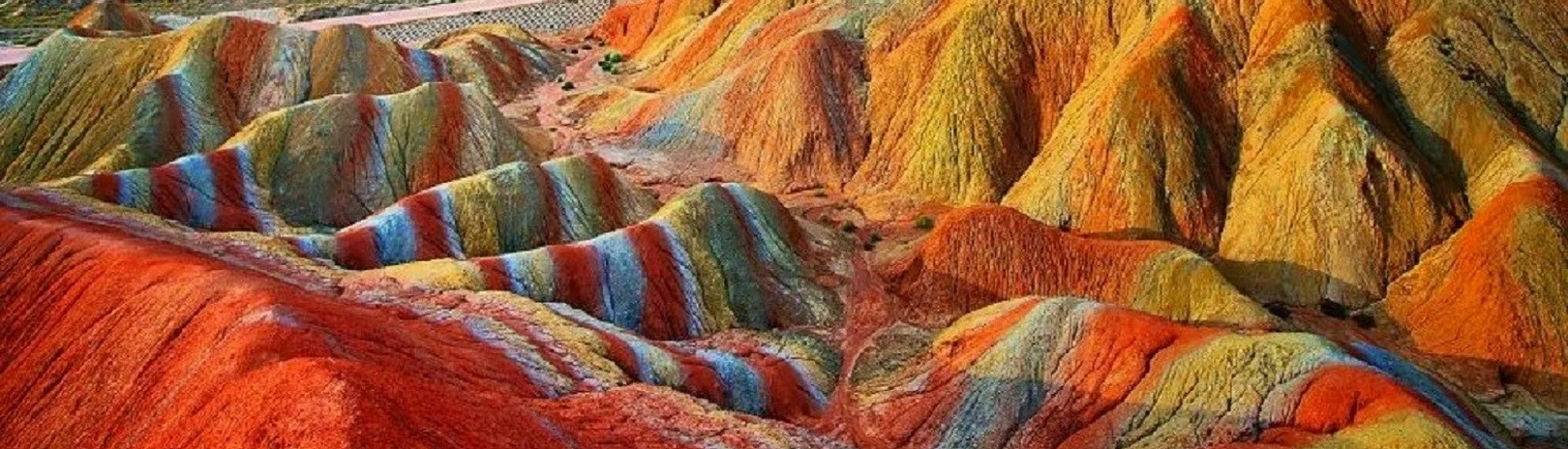
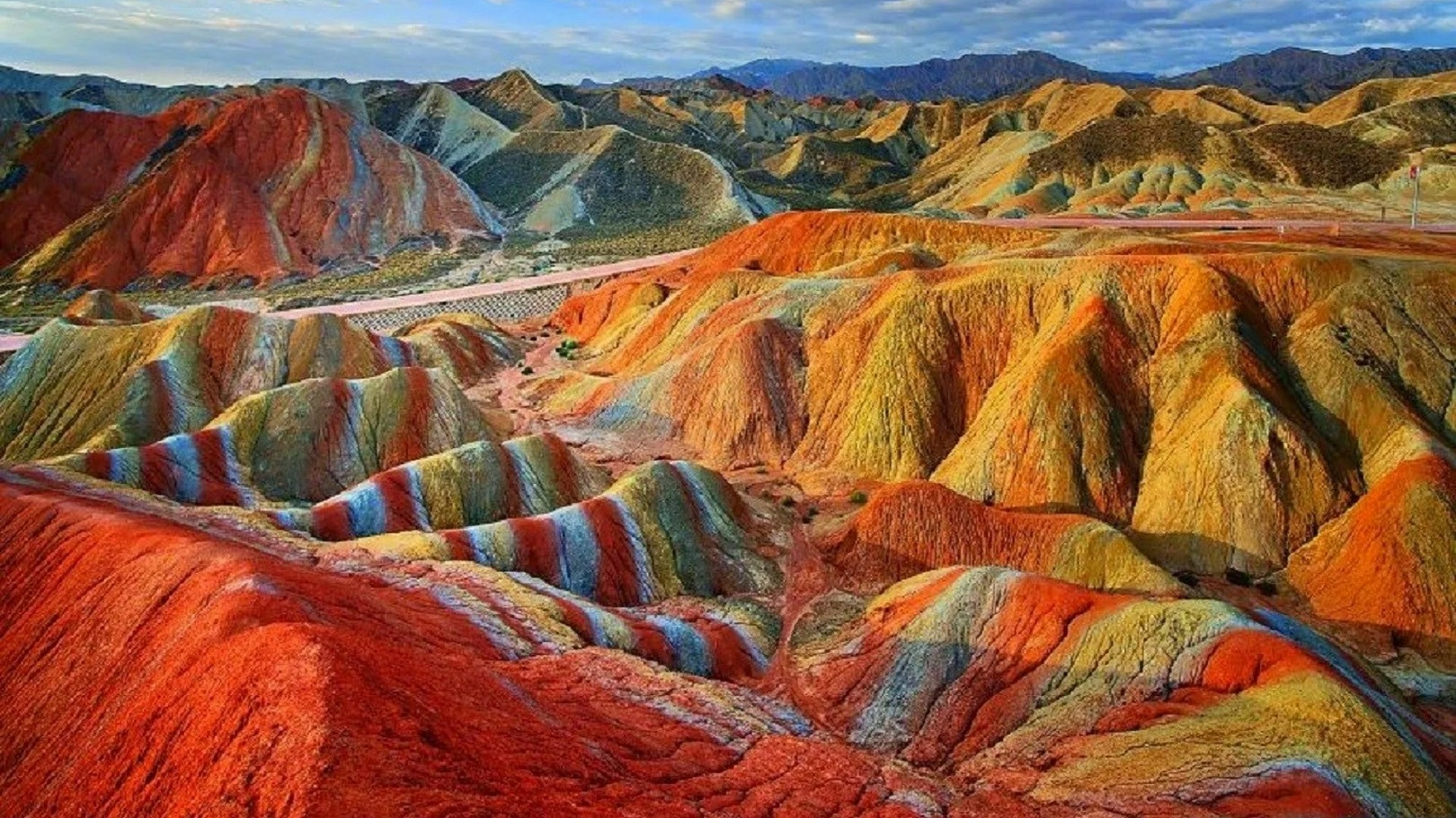
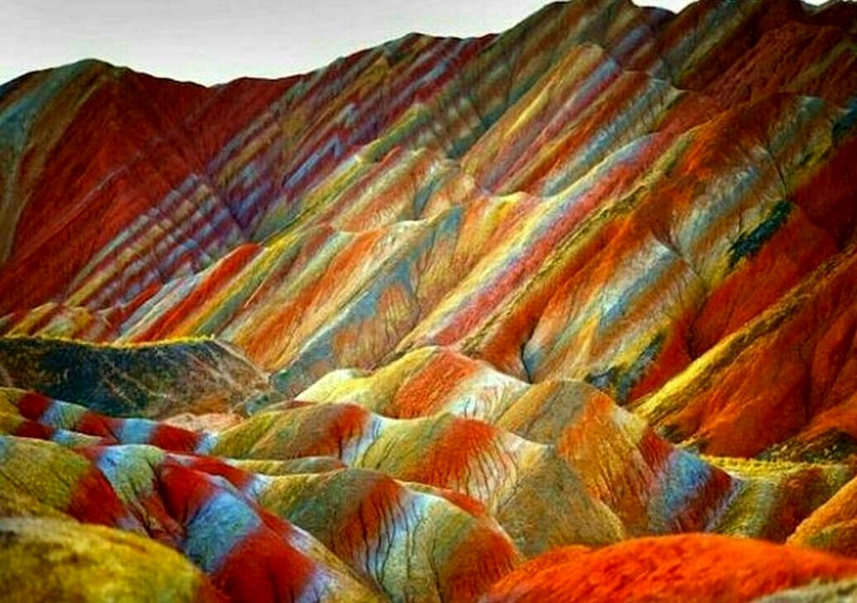
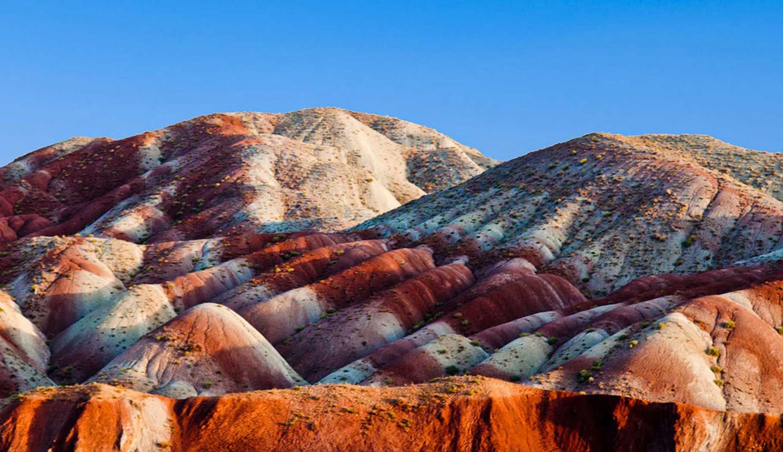
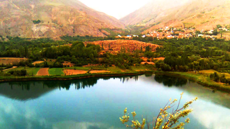
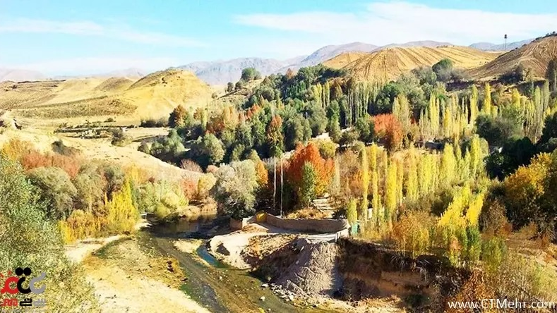
Aladaglar Mountains
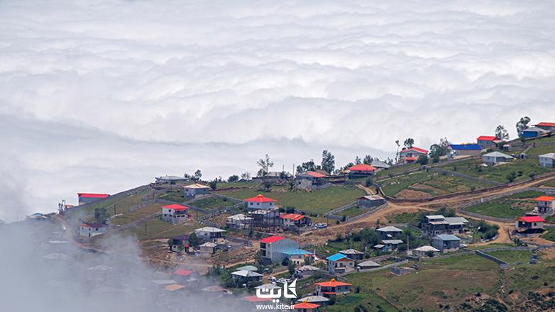
The climatic and geographical diversity of Iran is so great that it is possible to find all types of attractions that exist around the world, including cold regions, dry and burning deserts, wetlands with numerous plant and animal species, uninhabited areas, all kinds of valleys, caves, foothills and plains. This variety of attractions can make every tourist with any taste enjoy visiting Iran and its incredible nature.
Aladaghlar Mountains of Iran are famous for their diverse and strange colors. These mountains are located in the two provinces of Zanjan and East Azarbaijan, and passing through the busy highway from Zanjan to Tabriz has made it easy for everyone to access them.
There are also mountains named “Aladaghlar” in the southern regions of Türkiye and perhaps this similarity in name has caused the Aladaghlar mountains of Iran to be less well-known to foreign tourists. However, the beautiful view of these mountains is one of the rarest natural landscapes in the world.
Features of Aladaghlar Mountains
Zanjan and East Azarbaijan provinces are located in the northern part of Iran and adjacent to each other. Due to their geographical location, these two provinces have a milder climate than many regions of Iran. There are several volcanic peaks in these two provinces that have been inactive for years. There are also many glacial lakes in the highlands of this region. However, Aladaghlar Mountains - with such colors as green, red, yellow, white, and orange, which stand out like a work of art - are the most outstanding and must-see tourist attraction of these two provinces.
According to experts, like China’s Zhangye mountains, Aladaghlar Mountains of Iran have, as a result of the compression and oxidation of minerals and sandstones, turned into different colors over millions of years.
The Feeling of Being on Another Planet!
Aladaghlar is like a rainbow that has appeared on the earth and not in the sky. For this reason, many tourists consider being in the middle of these mountains a good opportunity for photography and recording their moments in the region. The variety of colors of these mountains, which in some areas become more apparent for being in contrast with the colors of the adjacent layers, creates an otherworldly atmosphere, making one feel as if he or she has travelled to another planet.
With streams flowing in the heart of the mountains during the rainy seasons, the contrast between the running water and the multi-colored bed of these steams becomes indescribable. Also, the rains on these mountains make the various colors of different layers more transparent and visiting them more pleasant. By the same token, the reflection of sunlight on the body of these mountains is also spectacular. Aladaghlar Mountains can, therefore, be described as a landscape that has many beauties to flaunt about.
Where Are Aladaghlar Mountains Exactly Located?
These mountains cover a total of about 70 square kilometers of Zanjan and East Azarbaijan provinces. They start in Khajeh (Heris) County, 25 km northeast of Tabriz, and continue until Ahar. Another part these mountains extends to Miyahen in the southeast of Tabriz. Traveling on the Tabriz to Zanjan highway makes it possible to see parts of these mountains. Aladaghlar Mountains can also be seen in Mahneshan County of Zanjan Province.
The climatic and geographical diversity of Iran is so great that it is possible to find all types of attractions that exist around the world, including cold regions, dry and burning deserts, wetlands with numerous plant and animal species, uninhabited areas, all kinds of valleys, caves, foothills and plains.
| Name | Aladaglar Mountains |
| Country | Iran |
| State | East Azerbaijan |
| City | Tabriz |
| Type | Natural |
| Registration | No registration |
 در تخت جمشید_crop_2.jpg)


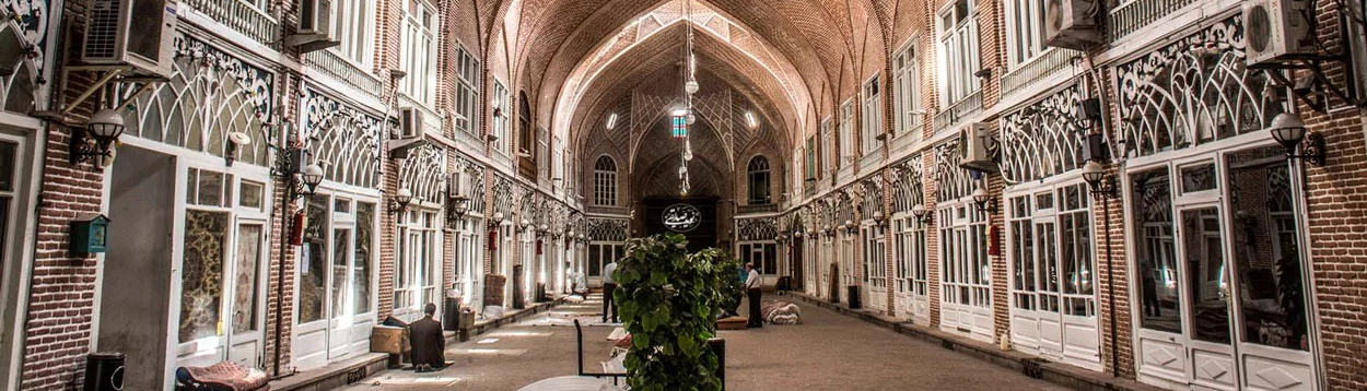
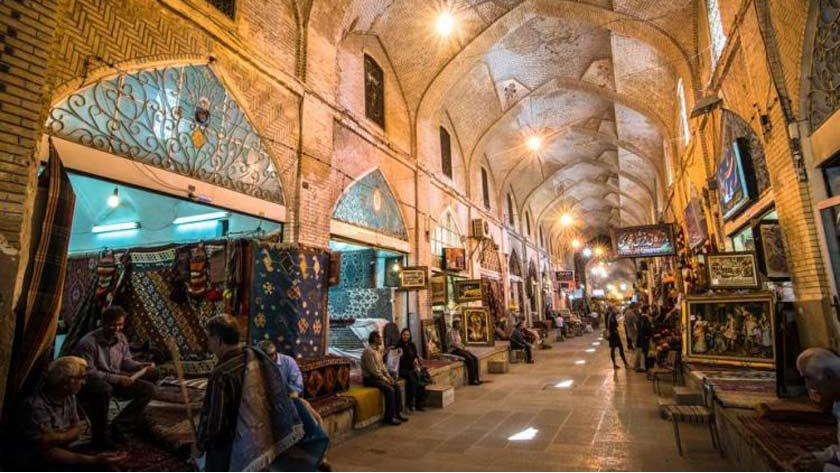
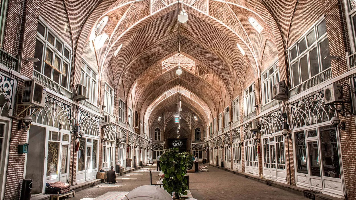
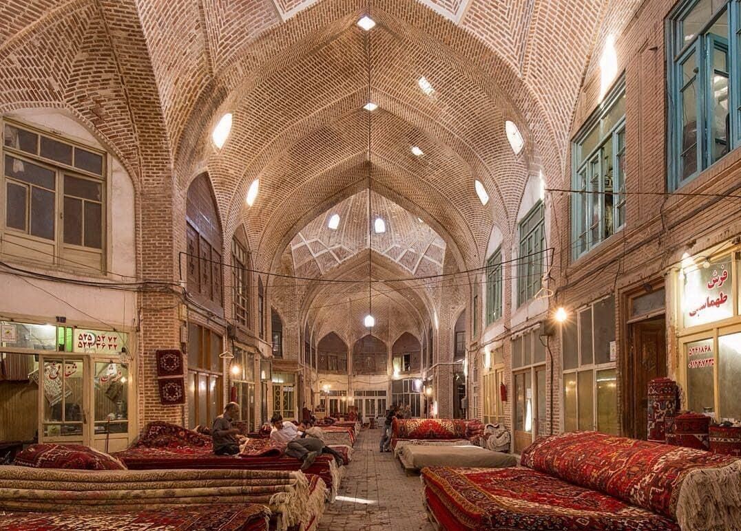
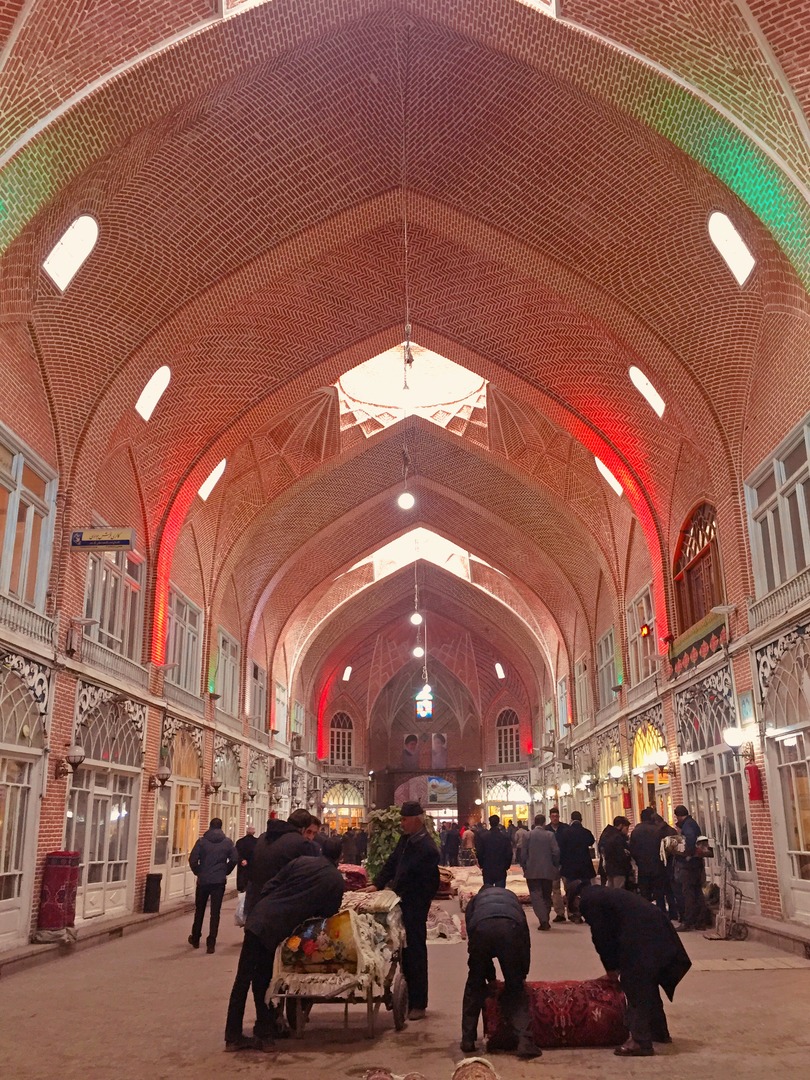
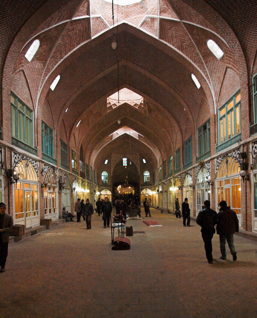
Historical Bazaar of Tabriz; the Largest Covered Bazaar in the World
Bazaar has always been the most important economic pillar in Iranian cities and this is the reason that most of the historical cities of Iran have bazaars that still maintain their efficiency. The Historical Bazaar of Tabriz is also one of these traditional markets, which has been the center of economic activities of this city since the distant past.
Almost all the foreign tourists who have traveled to Tabriz since the distant past have mentioned this bazaar in their travelogues and written about the variety of goods including fruits, precious fabrics, precious and semi-precious gems, and jewelry found in this market. The Historical Bazaar of Tabriz is one of the most important tourist attractions of this city, which must be included in the itinerary of every tourist who visits it!
History
Tabriz was located on the east-west trade route. The Silk Road, which once connected East Asia to North Africa and Europe and was the largest communication highway of the world trade network for 1700 years, passed near Tabriz and this made this city gain strategic importance.
Although the historical and geographical position of Tabriz had resulted in the foundation of many commercial infrastructures, the establishment of the Bazaar of Tabriz dates back to the Seljuq era (12th century AD). After the Mongol invasion of Baghdad in the 13th century and the destruction of this city, Tabriz became the center of attention resulting in the increasing prosperity of this city. Ibn Battuta and Marco Polo, two famous travelers of the 14th century AD, have described Tabriz as one of the richest cities in the world of the time in their travelogues.
Although after the coming to power of the Safavids in the 16th century Tabriz maintained its glory, this city faced decline when Shah Abbas I moved the capital of the country from Tabriz to Qazvin. Nevertheless, through the efforts of its people, Tabriz managed to regain its position as one of the most important cities in northwestern Iran.
In the 18th century, a terrible earthquake almost completely destroyed Tabriz, and its bazaar, too, suffered a lot of damage. But being economically important, it was restored after some time and regained its glory. It seems that the current structure of this bazaar was created by a person named “Najaf Qoli Khan Danbali”, who was the governor of Tabriz at that time, about 300 years ago.
Architecture
The historical market of Tabriz is a complex in which there are several caravanserais, markets, and passages. These parts have been gradually formed and integrated according to the requirements of the time. The most prominent parts of this historical bazaar include the Amir Bazaar, which is a gold and jewelry market, the Mozaffariyeh Bazaar of carpets, and the Shoe Sellers’ Bazaar. The Historical Bazaar of Tabriz, which is the largest covered bazaar in Iran and the world, is located over an area of nearly one square kilometer.
Most of the arcades of this bazaar are built on three floors, the lower floor accommodates the warehouses, the ground floor is the trading place, and the upper floor is the resting place. The main corridors of the bazaar are connected with several sub-corridors, which house the arcades. The crossroads of these corridors are covered with brick arches. the largest of these arches is that of the Amir and Bazaar and the most beautiful of them is that of the Mozafariyeh Bazaar.
There are also several traditional teahouses in this bazaar, the layout and interior decorations of which represent a part of Iran’s history. There were also some caravanserais in this market, which were a resting place for commercial caravans. Certain chambers had been prepared in these caravanserais for the passing caravans to sell their goods.
The Historical Bazaar of Tabriz was inscribed on the list of Iran’s national heritage in 1975 and as one of Iran’s UNESCO World Heritage Sites in the year 2010.
Almost all the foreign tourists who have traveled to Tabriz since the distant past have mentioned this bazaar in their travelogues and written about the variety of goods including fruits, precious fabrics, precious and semi-precious gems, and jewelry found in this market.
| Name | Historical Bazaar of Tabriz; the Largest Covered Bazaar in the World |
| Country | Iran |
| State | East Azerbaijan |
| City | Tabriz |
| Type | Historical |
| Registration | Unesco |

 در جنوب میدان نقش جهان واقع است_crop_1.jpg)
.jpg)

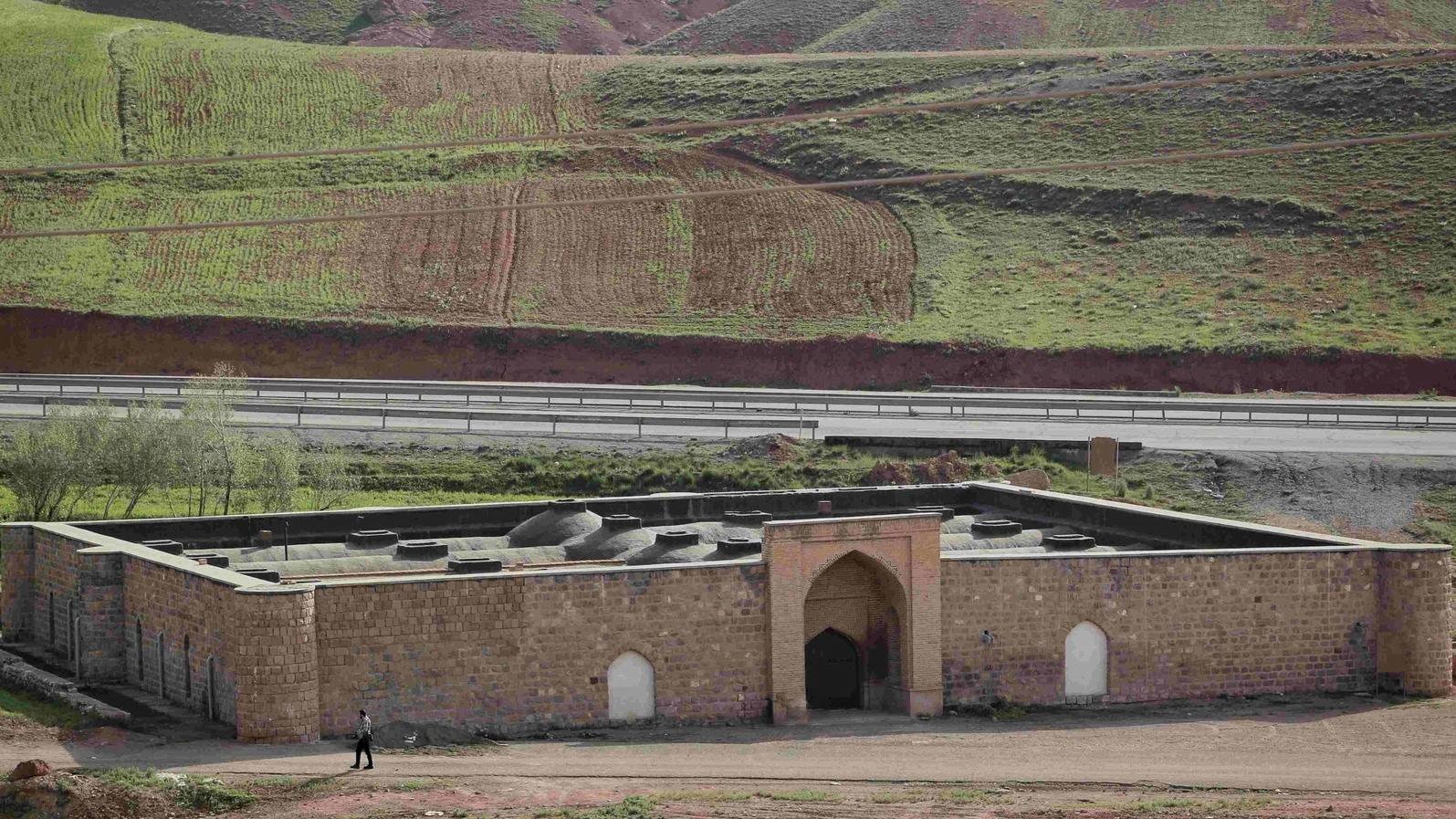

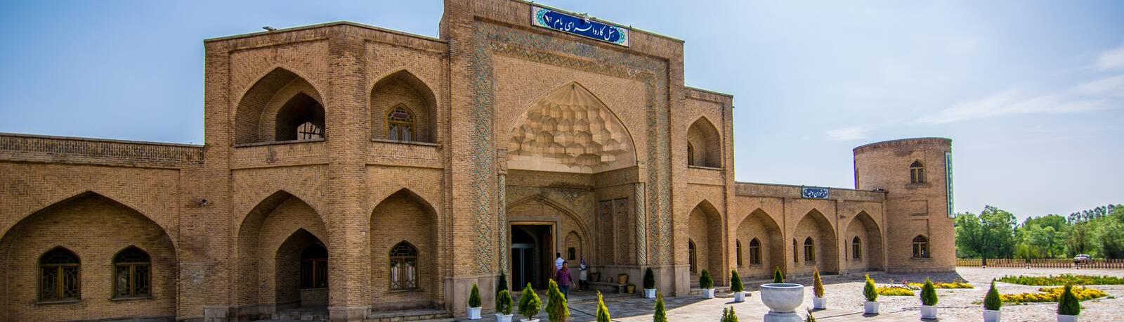
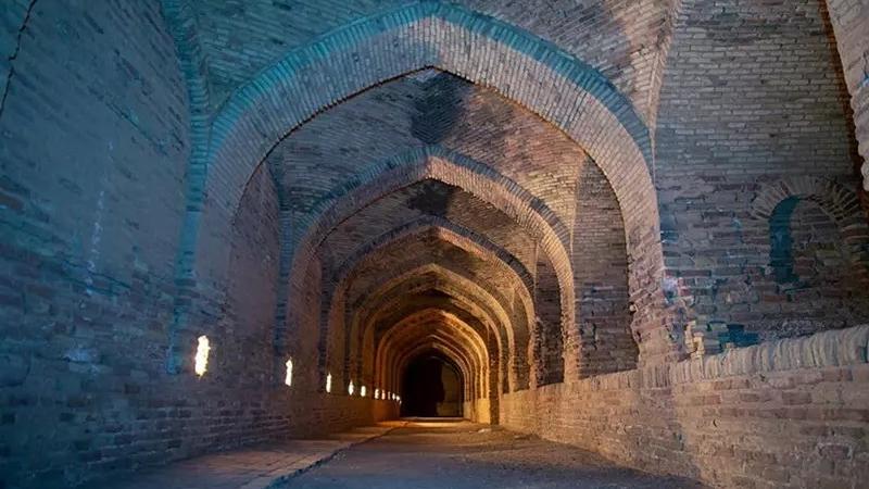
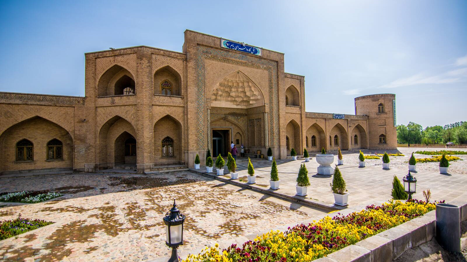
Yam Caravanserai, the largest caravanserai in northwestern Iran
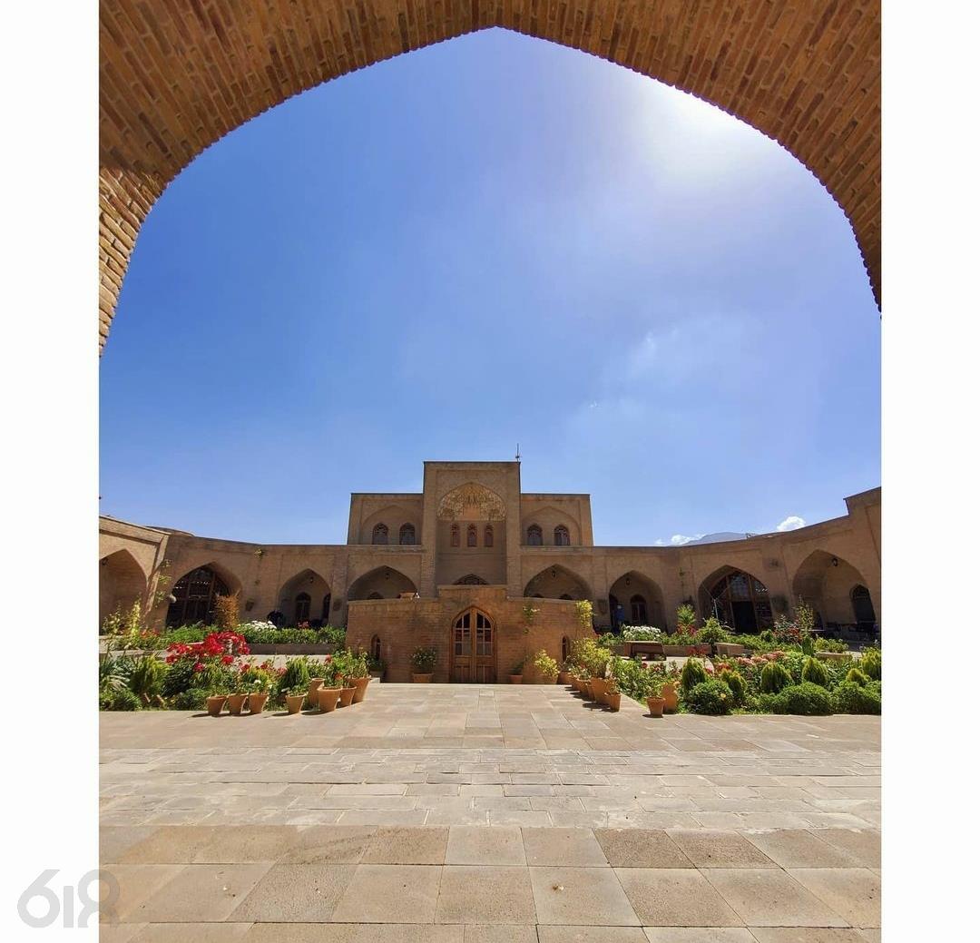
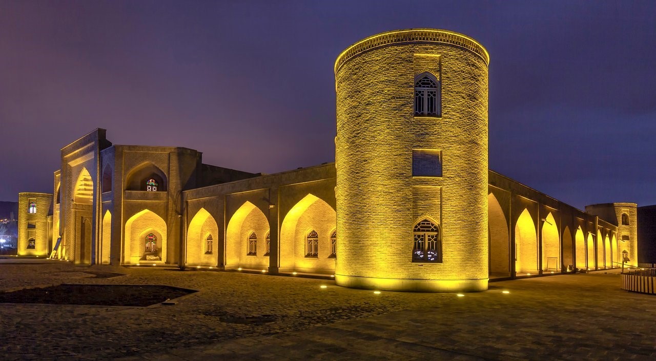
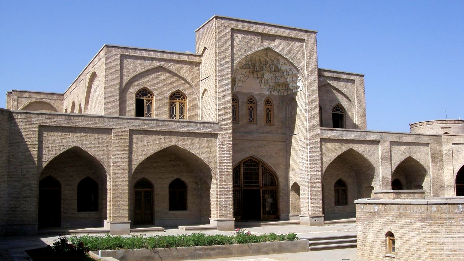
In the past, before modern transportation existed, moving goods and passengers was extremely challenging. In addition, road security was a major concern for governments. For this reason, caravanserais were established along main routes to facilitate travel and ensure the safety of caravans. Iran is home to numerous caravanserais, many of which are unparalleled in architectural design. The Yam Caravanserai in Marand—also known as the “Shah Abbasi Caravanserai” or “Payam Caravanserai”—is the largest caravanserai in northwestern Iran and historically played a vital role in communication and transportation.
History of the Yam Caravanserai in MarandThe original structure of the caravanserai dates back to the Ilkhanid era (13th–14th centuries CE). Its designation as a “Shah Abbasi” caravanserai likely relates to renovations carried out during the reign of Shah Abbas I of the Safavid dynasty (16th century CE). During his rule, Shah Abbas established and restored numerous caravanserais to promote trade and ensure the security of roads, several of which have survived to the present day.
Features and Architecture of the Yam Caravanserai in Marand
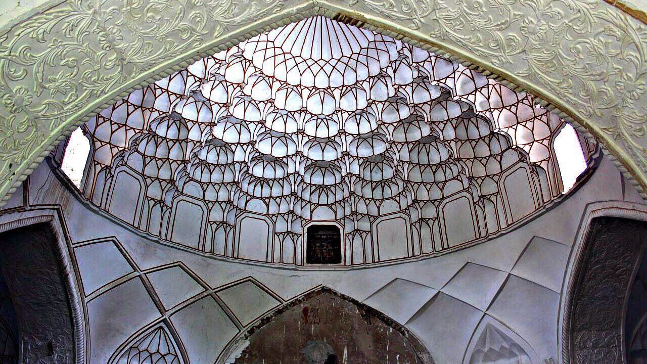
This caravanserai, located along the Silk Road, was one of the most important lodging and service structures of its time. Following the style of Iranian caravanserais, it has a large central courtyard surrounded by rooms, all of which face the courtyard. A continuous iwan (porch) connects the rooms to the courtyard, a design commonly referred to as a “four-iwan” layout. The overall plan of the caravanserai is rectangular, measuring 62 meters in length and 48 meters in width. To enhance security and structural stability, brick circular towers were built at each of the four corners, each with a diameter of about seven meters. These towers not only served as watchtowers but also as places to light fires at night, helping caravans traveling from distant regions to find their way.
The caravanserai features a tall entrance and an elevated gateway to facilitate the passage of pack animals and their loads. Additionally, a small dome is part of the structure, adding to its architectural character. The climatic conditions of the region over several centuries had caused the Yam Caravanserai to deteriorate. As a result, restoration work on the structure began in 1999 (1378 AH). Today, the caravanserai has once again become a suitable place for tourists and travelers to stay and is also used as an inn.
Where is the Yam Caravanserai in Marand located?
The village of Yam (Payam) in Marand, situated 13 kilometers along the Marand–Tabriz road, is the closest settlement to the caravanserai. The word “Yam” in the Mongolian language also means “Chapar.” Chapars were official couriers during the Achaemenid period (1st millennium BCE), responsible for delivering messages across different regions of the country. This name reflects both the antiquity of Yam village and its historical importance along communication routes.
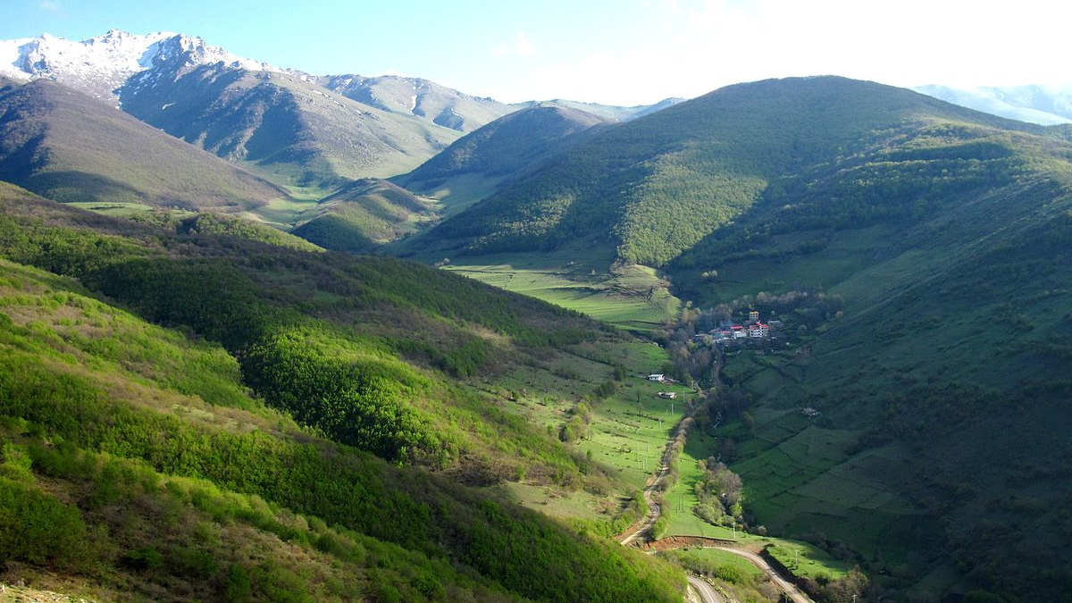
The village boasts stunning natural scenery, and visiting it not only allows a tour of the Yam Caravanserai—built on the slopes of the Mishou Mountains—but also offers opportunities to enjoy the surrounding landscapes. The Mishou Mountains lie between the Marand and Shabestar counties, with the summit of “Ali Alamdār,” at 3,200 meters, being the highest point.
In spring, the plains surrounding the village are covered with a red carpet of poppies, and in summer, the weather in the region is very pleasant and enjoyable. Therefore, the best time to visit this caravanserai is during the spring and summer seasons. However, traveling in the colder months also provides the opportunity to use the Yam ski slope.
National and World Registration of the Yam CaravanseraiThe Yam Caravanserai was inscribed on Iran’s National Heritage List in 2011 (1390 AH). This caravanserai was among the 56 Iranian caravanserais nominated in 2023 for inscription on the UNESCO World Heritage List. However, the evaluation committee of the organization, in a session held in Riyadh, announced that due to the use of modern materials in the restoration of the caravanserai, its authenticity was not convincing. As a result, the structure was removed from Iran’s nomination list.
| Name | Yam Caravanserai, the largest caravanserai in northwestern Iran |
| Country | Iran |
| State | East Azerbaijan |
| City | Marand |
| Type | Historical |


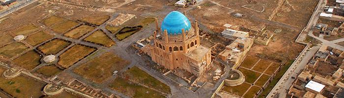
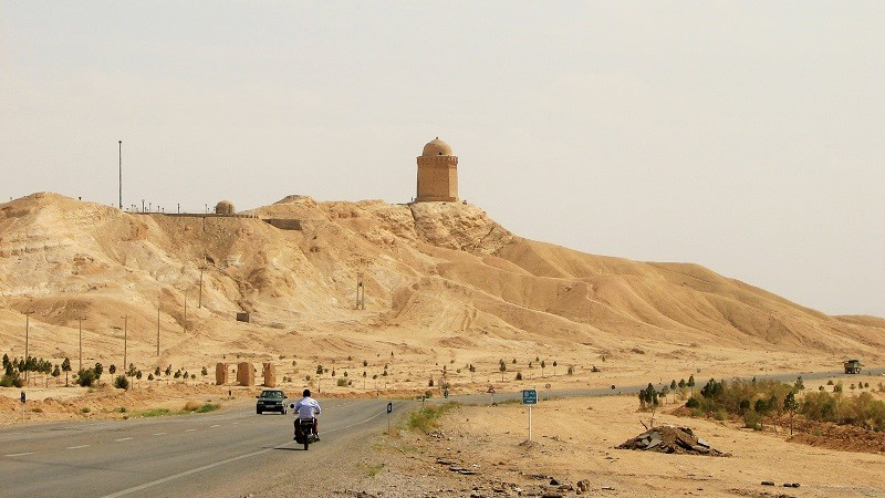
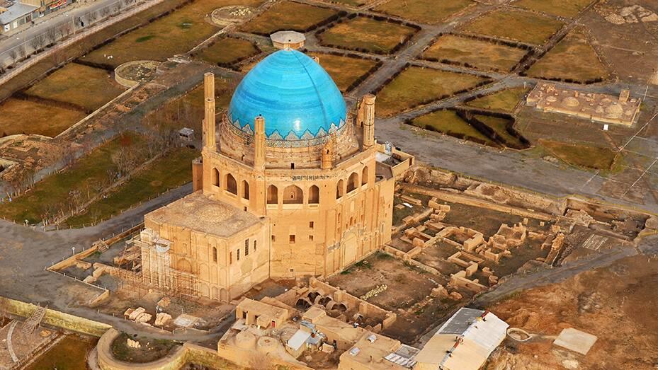
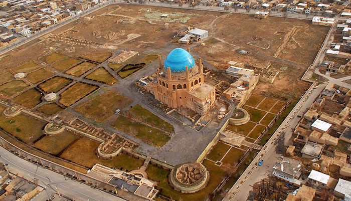
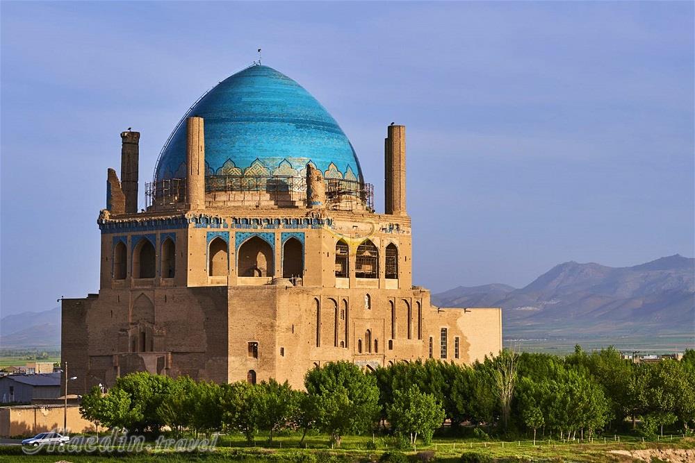
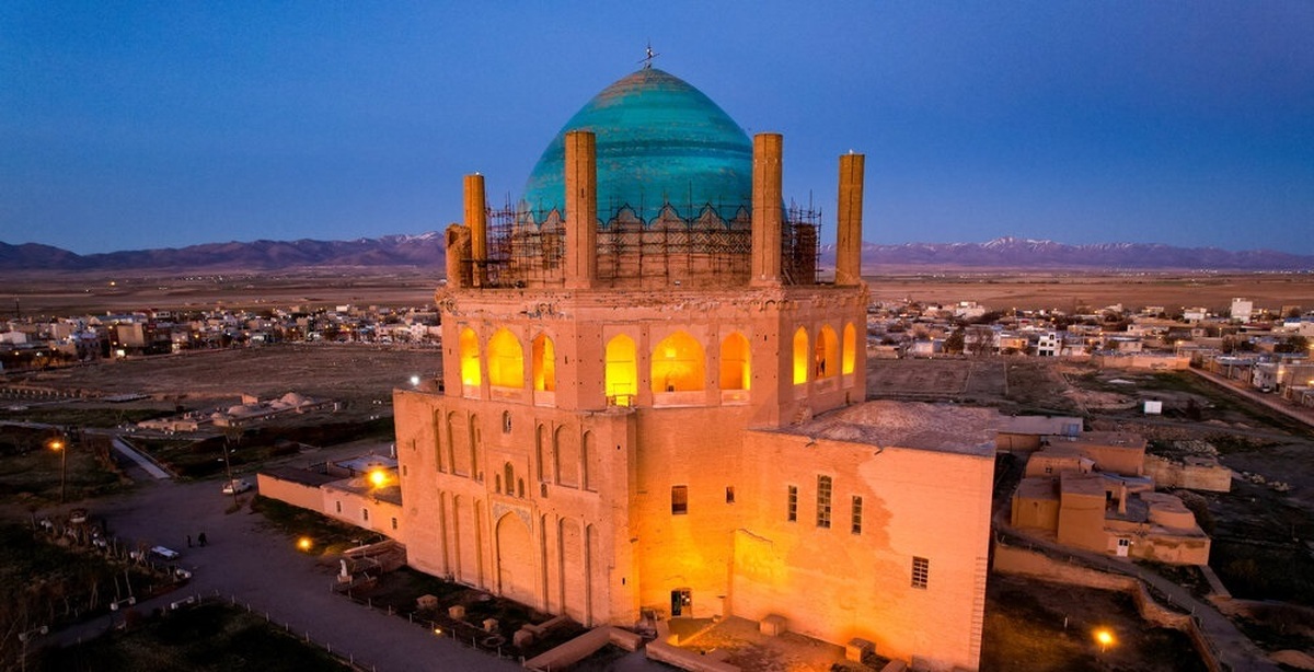
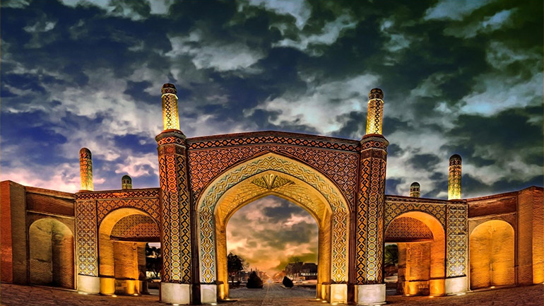
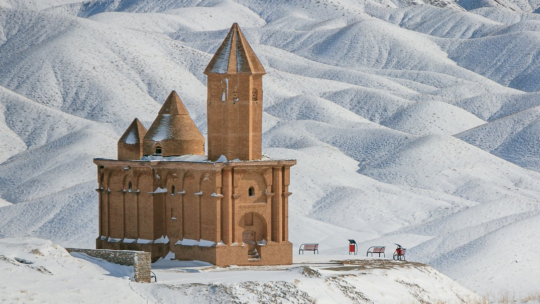
Visiting the Largest Brick Dome in the World — The Soltaniyeh Dome Complex
Perhaps comparing a tourist attraction or an ancient monument to more globally recognized landmarks can help introduce it
more effectively, especially for travelers visiting a foreign country who may be unfamiliar with its culture, history, society, and heritage. However, doing so is not easy, as many historical sites have no true counterparts anywhere in the world! The Dome of Soltaniyeh, for instance, despite often being compared to the dome of Santa Maria del Fiore in Florence and the dome of Hagia Sophia in Istanbul because of its height, possesses unique features found nowhere else on Earth. This magnificent dome is the most famous surviving monument of the ancient city of Soltaniyeh, and it has been inscribed on the UNESCO World Heritage List.
History of the Dome of Soltaniyeh
Archaeological excavations indicate that human settlement in the Soltaniyeh region dates back to the first millennium BCE. However, it was Arghun Shah, the fourth ruler of the Ilkhanid dynasty, who, in the late 13th century CE, recognized the importance of this area due to its strategic location between Marv and Maragheh, two major Ilkhanid administrative centers, and began developing it. The Ilkhanids ruled over Iran from 1256 to 1356 CE. Thanks to its vast pastures and fertile fields, Soltaniyeh served as an ideal site for the settlement of the army and royal residences. Arghun Shah built a summer palace in the region. After him, Sultan Muhammad Khodabandeh (Oljeitu) and Sultan Abu Sa’id also contributed to the city’s prosperity. However, Ghazan Khan abandoned further development of Soltaniyeh and instead focused his attention on Tabriz, which led to the city’s decline. Despite this, Soltaniyeh eventually grew into one of the most flourishing cities of Iran, remaining a major caravan stop during the Safavid era (16th–17th centuries CE). Due to its heavy traffic, several caravanserais were built around the area to accommodate travelers and traders. Sultan Muhammad Khodabandeh, known as Oljeitu, played the most significant role in the prosperity of Soltaniyeh. He was the eighth ruler of the Ilkhanid dynasty and reigned over Iran from 1304 to 1316 CE (703–716 AH).
Oljeitu was born to a Christian mother and initially followed Christianity, but later converted to Islam. The Dome of Soltaniyeh, which today stands as the most famous monument of this ancient city, once formed the center of the royal citadel. The citadel was surrounded by a massive defensive wall, about 12 meters high, so thick that four horsemen could ride side by side on top of it! Beyond the wall, a moat was also excavated to further strengthen the fortress’s defenses. Some historians believe that the construction of the Soltaniyeh Mausoleum was inspired by Oljeitu’s deep devotion to the Shi’a Imams. It is said that Oljeitu initially intended to build a grand tomb to transfer the remains of Imam Ali and Imam Hussein to it. However, opposition from Shi’a scholars—citing the religious prohibition against exhumation in Islam—prevented him from doing so. Nevertheless, Oljeitu proceeded with the project, modifying the original design, and ordered that his own body be buried in the crypt beneath the monument after his death. The renowned Ilkhanid vizier Fazlollah Hamadani oversaw the architectural design of the structure, while Seyyed Ali Shah, the chief architect, directed three thousand workers to complete the magnificent dome in ten years. The brickwork alone took three years to finish, reflecting the remarkable craftsmanship and attention to detail of the era.
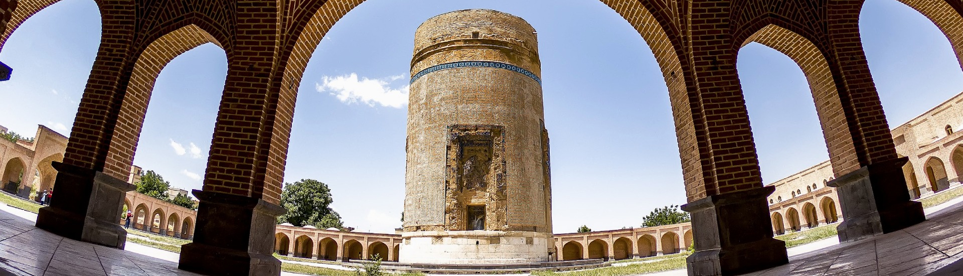
Architecture of the Dome and Mausoleum of Soltaniyeh
During the Ilkhanid period, many tall and monumental structures were built, several of which still stand today, with examples visible in cities such as Maragheh. Yet, no structure better demonstrates the mastery of Ilkhanid architects than the Dome of Soltaniyeh. The Dome of Soltaniyeh is the third-tallest dome in the world and the largest brick dome ever constructed. These features alone attest to the remarkable advancement of architecture and related sciences, such as mathematics, in Iran during that era. Around the Soltaniyeh Mausoleum, several other buildings once stood, though most have disappeared over time. The mausoleum itself is built of brick and mortar (sarooj). A variety of decorative techniques — including brickwork, plasterwork, inscriptions, tilework, and mural painting — can still be seen within the monument.
Although much of the interior decoration has suffered damage over the centuries, the majesty of the Soltaniyeh complex continues to astonish visitors. The structure has a rectangular plan, consisting of several main sections, which can be described as follows:
The Dome Chamber
This section of the structure is octagonal, with an entrance on each of its eight sides, symbolizing the eight gates of Paradise. Within the dome chamber, one can admire some of the most exquisite decorations of Ilkhanid architecture. In the upper part of the building, each side contains three rooms, each featuring a window that opens to the exterior, allowing light to enter the space. The ceilings of these rooms are adorned with stucco decorations and colored brickwork, showcasing refined craftsmanship. A staircase connects the ground floor to these upper rooms. On the first floor, a large mihrab with a tall arch can be seen, richly decorated with raised Qur’anic inscriptions. The floor of the structure, covered with smooth white marble slabs, enhances the interior’s luminous and majestic appearance.
The dome rises to a height of 48.5 meters and has a diameter of nearly 25.5 meters. The total weight of this massive structure is estimated at around 200 tons. To support such an enormous load, various parts of the structure were interlocked with toothed wooden beams, providing flexibility and strength. Pine wood was used for this purpose due to its resilience and lightness. Although the foundation of the building extends only about 90 centimeters into the ground, the Dome of Soltaniyeh has remarkably withstood numerous devastating earthquakes over several centuries — a testament to the advanced engineering and structural ingenuity of Ilkhanid architects.
The Turbatkhaneh (Sanctuary of Sacred Soil)
This section of the monument is attached to the southern side of the main dome chamber. It is believed that the Turbatkhaneh was constructed after the completion of the dome. According to historical accounts, when Oljeitu abandoned his plan to transfer the remains of the Shi’a Imams, he decided instead to build a chamber using soil from their holy shrines.
In various parts of this section, verses from the Holy Qur’an—written in Thuluth and Kufic scripts—were inscribed using soil from the tomb of Imam Hussein. The interior was decorated with golden tiles, creating an atmosphere of reverence and splendor. In earlier times, the Turbatkhaneh featured a large door made of copper and gold, though today no trace of that magnificent entrance remains.
The Crypt (Sardābeh)
Beneath the Turbatkhaneh lies an underground chamber known as the crypt (sardābeh). It was customary among the Ilkhanid rulers to bury their dead in crypts beneath monumental structures. Although no visible tombs remain in this section today, some historians believe that several Ilkhanid nobles, including Sultan Muhammad Khodabandeh Oljeitu himself, were interred here. The crypt features a network of interconnected corridors and passageways, reflecting the architectural precision characteristic of Ilkhanid funerary design.
The Minarets of the Dome of Soltaniyeh
At each corner of the octagonal structure of the Dome of Soltaniyeh, minarets were constructed, encircling the great dome. Although these minarets are not richly decorated, they harmonize beautifully with the turquoise-blue dome and the overall composition of the monument. Traditionally, minarets served purposes such as calling the faithful to prayer, making public announcements, or observing the surroundings. However, in the case of Soltaniyeh, the minarets had an additional structural function: because the dome’s immense weight created the risk of outward thrust, the minarets were built to counterbalance this pressure and prevent the dome from collapsing. Over the centuries, large portions of the minarets have crumbled, yet they successfully fulfilled their structural purpose, ensuring the stability and survival of the magnificent dome for more than seven hundred years.
Where Is the Dome of Soltaniyeh Located?
The ancient city and mausoleum of Soltaniyeh, commonly known as the Dome of Soltaniyeh, is located about 40 kilometers west of the city of Zanjan. The Zanjan–Qazvin highway passes near this historic site, making it easily accessible to visitors.
National and World Heritage Registration
Soltaniyeh was inscribed on Iran’s National Heritage List in 1932 (1310 AH). Later, in 2005 (1384 AH), it was added to the UNESCO World Heritage List, becoming the seventh Iranian site to receive this prestigious recognition.
| Name | Visiting the Largest Brick Dome in the World — The Soltaniyeh Dome Complex |
| Country | Iran |
| State | Zanjan |
| City | Soltaniyeh |
| Type | Historical |
| Registration | Unesco,National |
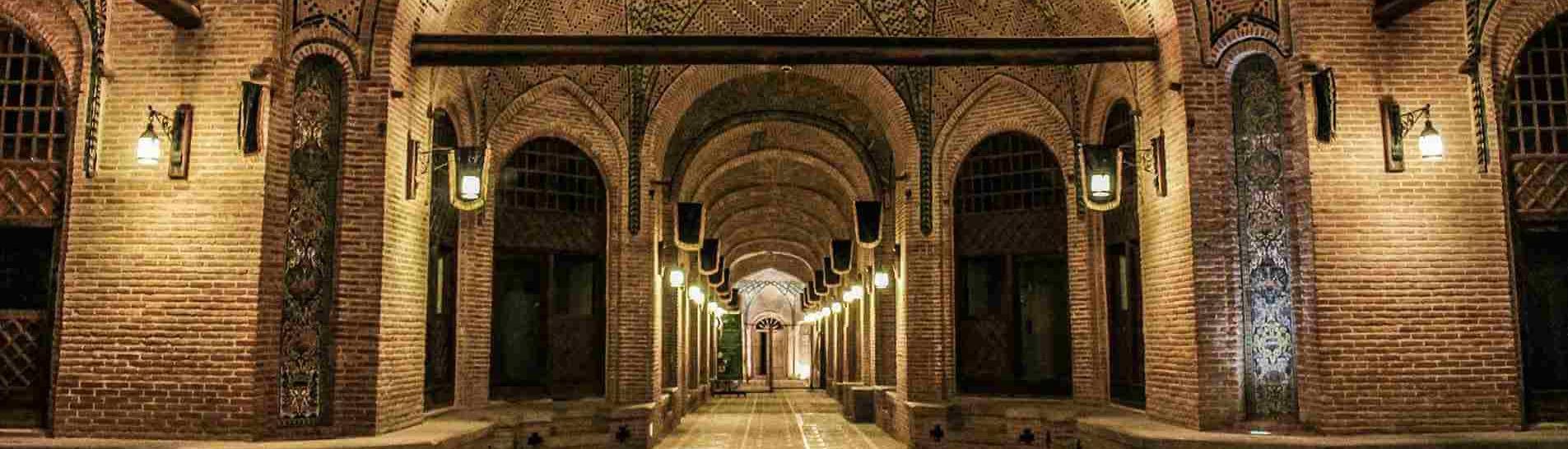
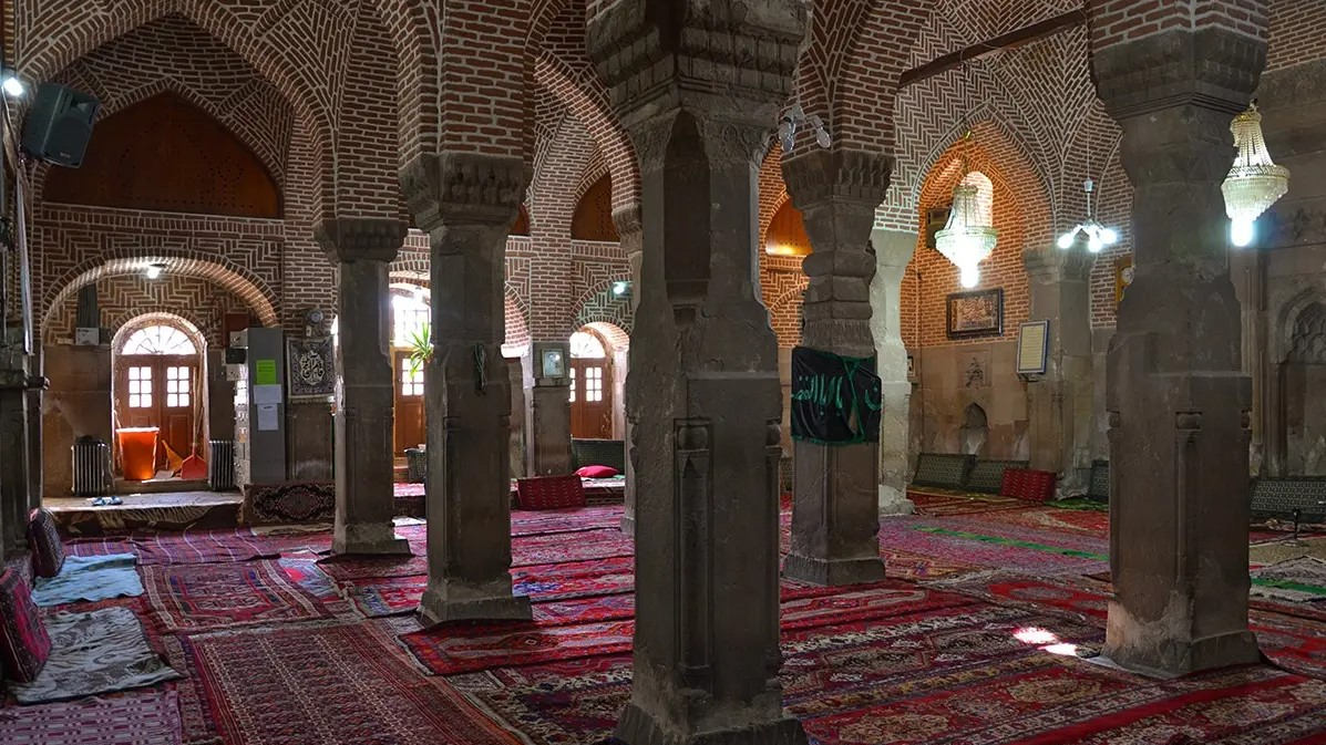
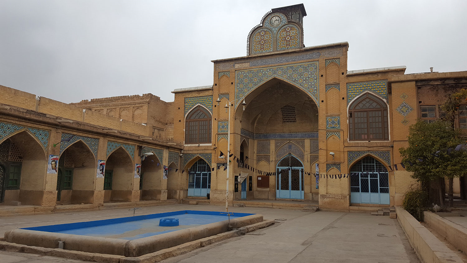
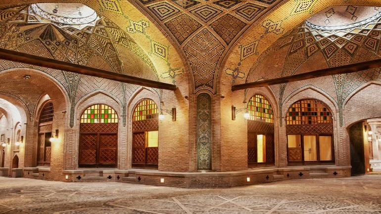
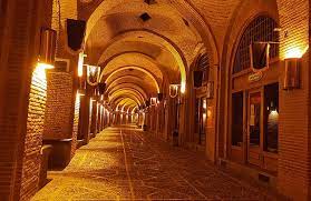
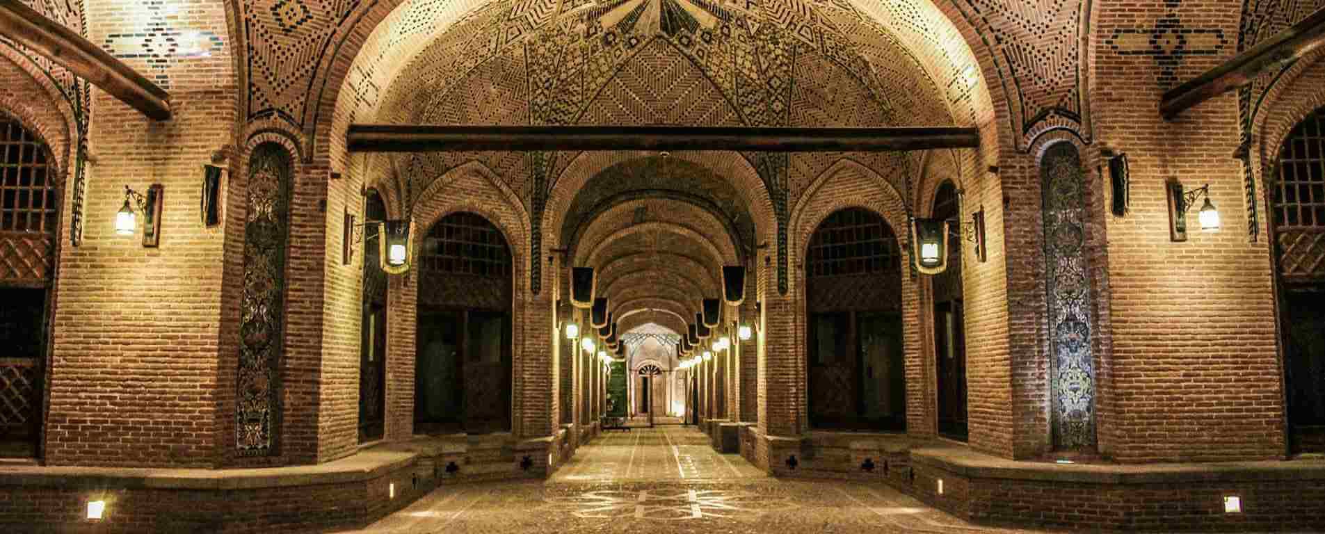
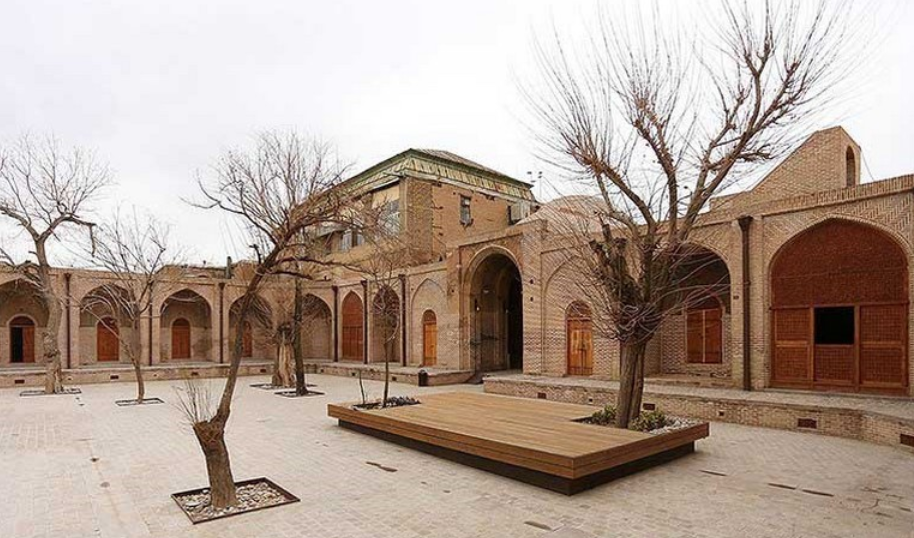
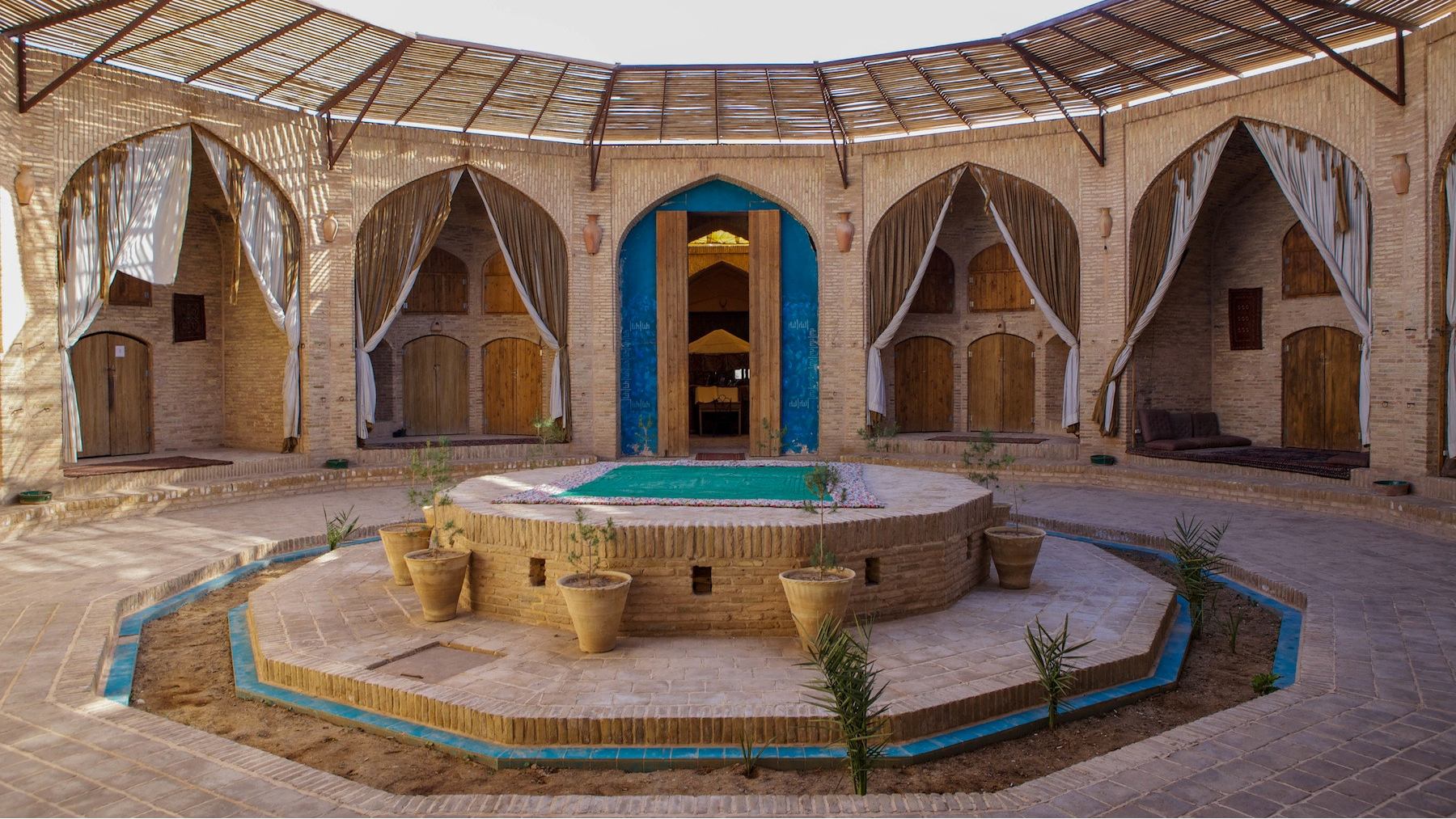
Sa’d al-Saltaneh Caravanserai: The Largest Urban Caravanserai in Iran
Caravanserais in Iran were facilities designed to serve traveling trade caravans, usually built along major routes between cities. At certain periods in Iranian history, caravanserais played a vital role in developing commercial infrastructure and ensuring the safety of roads, enabling merchants to earn significant profits. Not all caravanserais were located between cities; some were constructed within urban areas, often near bazaars. These urban caravanserais provided lodging for merchants, allowing them to stay and sell their goods conveniently. One notable example is the Sa’d al-Saltaneh Caravanserai in Qazvin, also known as Saray-e Sa’dieh, Bazaarcheh Sa’d al-Saltaneh, or Saray-e Sa’adat.
Construction and History of Sa’d al-Saltaneh Caravanserai
The Sa’d al-Saltaneh Caravanserai was built during the reign of Naser al-Din Shah Qajar, who ruled Iran from 1848 to 1896 (1227–1275 Solar Hijri), making his one of the longest reigns in Iranian history. The caravanserai was named after Baqer Khaneh Sa’d al-Saltaneh, who governed Qazvin at the time of its construction. Historically, Qazvin served as a key connection between east and west and a trade route linking Iran with Turkey and Europe. It was also considered a gateway to Tehran, so merchants and travelers often passed through the city on their way to the capital. Sa’d al-Saltaneh established the caravanserai next to Qazvin’s bazaar to facilitate commercial interactions. Construction began in 1892 (1271 Solar Hijri) and was completed in two years, involving two architects from Isfahan and two from Qazvin. Until the start of World War II, the caravanserai served as a resting place for travelers and merchants, but afterward, due to economic difficulties, its rooms were converted into workshops and production spaces. By 1998 (1377 Solar Hijri), the structure had gradually fallen into ruin, but restoration efforts that year revived it, giving the caravanserai new life.
Architecture and Features of Sa’d al-Saltaneh Caravanserai
The caravanserai was built on a 2.7-hectare plot and contains nearly 400 rooms, making Sa’d al-Saltaneh Caravanserai the largest urban caravanserai in Iran. The building is designed in a four-iwan layout. The arches of the iwans are decorated with brickwork, and the ceilings feature intricate muqarnas. The main entrance of Sa’d al-Saltaneh Caravanserai is located on Imam Khomeini Street in Qazvin, leading directly into the main courtyard. In addition, the structure contains seven other courtyards throughout the complex:
-
Sa’d al-Saltaneh Courtyard: This courtyard covers more than 3,000 square meters, half of which is open space. 32 rooms surround the courtyard on all four sides, built on platforms approximately one meter above ground level.
-
Negar al-Saltaneh Courtyard: Located west of Sa’d al-Saltaneh Courtyard, it contains two rooms and two large storage areas. The courtyard connects westward to Rasteh-ye Vazir. Overnight stays were not allowed here; caravans had to leave the courtyard after unloading their goods. Negar al-Saltaneh Courtyard covers about 1,500 square meters, with 244 square meters of open space.
-
Ghahramani Courtyard: This area measures 1,860 square meters, with 706 square meters of open space. The rooms are on the same level as the courtyard. Ghahramani Courtyard is the only courtyard in the caravanserai without direct access to the outside.
-
Service Courtyard: No rooms were constructed in this courtyard.
-
Sa’dieh Courtyard: Located west of Sa’d al-Saltaneh Courtyard, it is considered the most beautiful of all courtyards. The courtyard covers 2,900 square meters and features decorative brick and tile work.
-
Shotor Khan Courtyard: This area spans 4,378 square meters. Caravans entered the caravanserai through this courtyard and unloaded their goods here. To the north, there is a large space called “One Hundred Columns”. The main loading and unloading area of the caravanserai was located in this courtyard.
-
Beheshtian Courtyard: Situated in the northwest of the complex, it contains two large halls, two iwans, and eight rooms, as well as a water reservoir.
The most beautiful part of the caravanserai is its Chaharsuq (central vaulted hall), crowned by a large, decorated dome. The vibrant yellow and turquoise tiles give the Chaharsuq an incomparable splendor. This hall connects the street to the main courtyard (Sa’d al-Saltaneh). On each of the dome’s four sides, semi-domes have been constructed to further enhance the architectural beauty. Additionally, three inscriptions display the year of completion and the names of the architects.
The Razavi Bathhouse, covering 1,800 square meters, is another significant part of the caravanserai. This bathhouse is independently registered on Iran’s National Heritage List. Other sections of the complex include the Sa’dieh Bathhouse, located northeast of Sa’dieh Courtyard, and Rasteh-ye Vazir in the west of the caravanserai, which has a built-up area of nearly 2,000 square meters and contains 44 shops. In addition to shops selling local products, the Sa’d al-Saltaneh Caravanserai also hosts cafés and restaurants for visitors. Several museums are established within the complex, including the Shahnameh Museum, Mythology and Anthropology Museum, and Dr. Salehi Museum.
National and International Registration of Sa’d al-Saltaneh Caravanserai
In 1937 (1316 AH), Sa’d al-Saltaneh Caravanserai was registered as part of the Qazvin Bazaar. However, after changes in its usage, it was independently registered in 1998 under its own name on Iran’s National Heritage List.
In 2023 (1402 AH), Sa’d al-Saltaneh Caravanserai became one of 54 Iranian caravanserais inscribed on the UNESCO World Heritage List, recognizing its historical, architectural, and cultural significance.
| Name | Sa’d al-Saltaneh Caravanserai: The Largest Urban Caravanserai in Iran |
| Country | Iran |
| State | Qazvin |
| City | Qazvin |
| Type | Historical |
| Registration | Unesco,National |


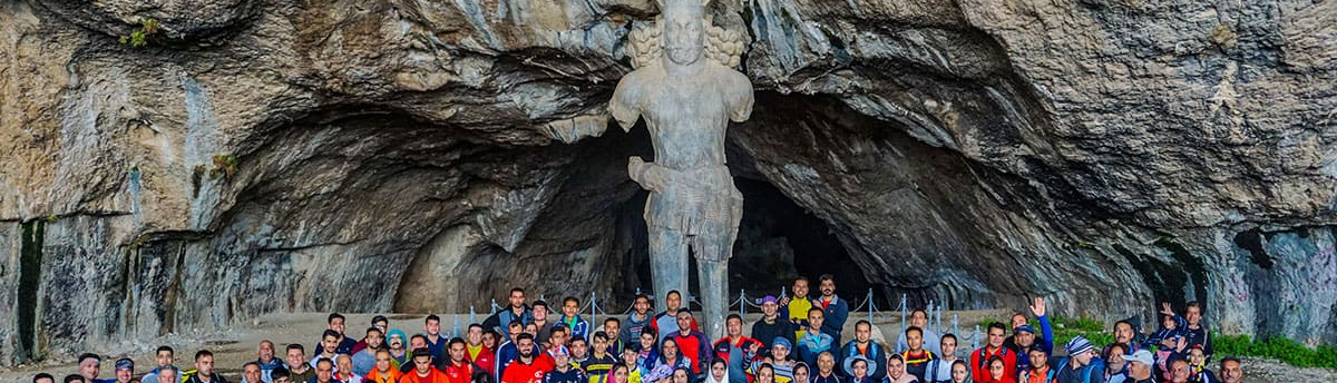
Shapour Cave, An Astounding Cave Housing the largest Statue of Ancient Iran
Shapour Cave
Located in the Chogan Valley of the Zagros Mountains near Kazerun, Shapour Cave lies approximately 6 kilometers from the ancient city of Bishapur. The cave’s most famous feature is the large statue of Shapour I, the second Sassanid king (reigned 240–270 AD), making it one of the most important tourist attractions in the region.
Features of Shapour Cave
Shapour Cave sits at an altitude of 800 meters. Its entrance measures 30 meters wide and 15 meters high, and the cave extends about 450 meters from the entrance to its end. The cave is named after Shapour I because of the impressive statue carved inside.
The seven-meter-tall statue, with shoulders about two meters wide, The statue is carved on one of the stalagmites of this limestone cave. A stalagmite is a column of mineral deposits formed over thousands of years by the dripping of mineral-rich water.
It was carved from a stalagmite around 1,700 years ago in the third century AD. It is the only statue of this size remaining from ancient Iran.
Who Was Shapour I?
Shapour I was one of Iran’s most powerful Sassanid kings, famous for defeating the Romans. In his final battle against Rome in 260 AD, he captured the Roman emperor and imprisoned him in Bishapur. The scene of the emperor’s surrender is depicted in Naqsh-e Rostam.
Other Sights in the Cave
The cave contains two stone inscriptions:
- An ancient inscription from the early Sassanid period, attributed to Shapour I.
- A modern inscription, explaining the restoration of the statue in 1957 AD, 14 centuries after it had been toppled following the advent of Islam in Iran.
Inside the cave are two small reservoirs dug into the rock, about one meter deep, accessible via steps. These were likely used by locals to collect water dripping from the cave ceiling. A small stream flows beside these reservoirs, surrounded by beautiful stalactites and stalagmites.
At the bottom of the cave lies a large depression, about 100 meters in diameter and 30 meters deep, formed from a dried lake. Beyond this hole is a flat area, thought by archaeologists to have been used for ceremonies or offerings, with a ceiling height of nearly 40 meters.
Local legends suggest that Shapour I’s body may be buried in the cave, while another story claims he took refuge here after a battle and was never seen again.
Visiting Shapour Cave
- Due to the region’s semi-arid climate, bring plenty of water if visiting in spring or summer.
- In autumn and winter, wear warm clothing, as sudden winds can make conditions uncomfortable.
- Access to the cave involves climbing 230 steps from the mountain’s foothill. A steeper, winding path is also available, so appropriate footwear is recommended.
Heritage Status
Shapour Cave was inscribed on Iran’s National Heritage List in 1932 and added to UNESCO’s World Heritage List in 2018.
| Name | Shapour Cave, An Astounding Cave Housing the largest Statue of Ancient Iran |
| Country | Iran |
| State | Fars |
| City | Caseron |
| Type | Historical |
| Registration | Unesco,National |


Choose blindless
Red blindless Green blindless Blue blindless Red hard to see Green hard to see Blue hard to see Monochrome Special MonochromeFont size change:
Change word spacing:
Change line height:
Change mouse type: